Our own Megan Butler filled up a bottle of water from the St. Marys River today to see how clear it really is. We will be spending the summer educating you on how our rivers are natural, where they get their appearance from, and how you can enjoy them! Our new website will debut soon with resources for you to enjoy.
It's #waybackwednesday! Take a look at this aerial view of the St. Mary's River and downtown Fort Wayne in 1924. This image comes from the Bert J. Griswold Collection in our Community Album. [showing what is now Headwaters Park at the confluence of the Three Rivers]
According to the United States Board on Geographic Names, it is correct to write St. Marys River, and incorrect to write St. Mary’s River. In all communications, Riverfront Fort Wayne will use St. Marys River, and will advocate for the elimination of St. Mary’s River in all other signage and communication. Copied from What happened to the apostrophe in the St. Marys River? posted 03/13/2017 on Riverfront Fort Wayne blog.
FUN FACT: Did you know that in 1910, the St. Marys River was officially named by the United States Geographic Board?
According to the Geographic Names Information System of the USGS (https://on.doi.gov/2qocPZz), while it was recognized that a variant name was "St. Mary's," the official name does not include the apostrophe.
Many people think rivers flow from north to south, but Fort Wayne’s rivers are great examples of rivers that don’t flow in the direction you think they might.
Fort Wayne sits on what is known as the St. Lawrence continental divide that separates the Great Lakes Basin from the Gulf of Mexico watershed. 🌊
Although the land around Fort Wayne is flat, the city is on a small ridge that resulted from receding glaciers that covered the area in the Ice Age. 🧊
The St. Joseph River begins in Hillsdale County, Michigan. It flows southeast into Ohio where it turns and flows southwest to Fort Wayne. 💦
The St. Marys River begins near Celina, Ohio. It flows northwest into Fort Wayne where it meets the St. Joseph River near Headwaters Park. 🦦
The two rivers combine to form the Maumee River. It flows in a northeasterly direction and ends at Toledo where it dumps into Lake Erie. 🌊
? What happened to the apostrophe in the St. Marys River?
According to the U.S. Board of Geographic Names, it is correct to write St. Marys River and incorrect to write St. Mary’s River. This is because the river is named St. Marys and isn’t a river that belongs to St. Mary. 🦦 💦
Navigability status of the St. Marys River a complicated issue published September 15, 2017 by The Journal Gazette newspaper.
St Marys and Maumee at Indiana Department of Natural Resources. The St. Marys River and Maumee River Watershed is located in northeastern Indiana, draining approximately 376 square miles in Adams and Allen counties. Major streams included in the Total Maximum Daily Load (TMDL) report are St. Marys River, Maumee River, Habegger Ditch, Gates Ditch, Blue Creek, Yellow Creek, Martz Ditch, Borum Run, Holthouse Ditch, Kohne Ditch, Gerke Ditch, and Nickelsen Creek, Trier Ditch, Bullerman Ditch, Gar Creek, Botern Ditch, Black Creek, Ham Interceptor Ditch and other tributaries.
It's #waybackwednesday! Take a look at this moonlight view of the St. Mary's River in Fort Wayne. This image is courtesy of the Harter Postcard Collection in our Community Album.
“This will allow aquatic life to migrate downstream instead of staying in one area, it will improve the ecological balance of the river and it will also protect the banks,” Suarez said.
The Lawton Park Spy Run Creek Dam is near the physical start of Spy Run Creek– however, the dam has long outlived its intended purpose. “The dam was put in when what is now Science Central was the electric plant,” Suarez said. “Nearly 100 years ago it was used to cool the turbines that were used to create electricity, and they wanted to have water backups so they would have a pool of water to cool those.” Copied from Fort Wayne dam may be demolished; city cites ecological factors
At the last meeting of the council the sewer committee recommended that proceedings be taken by the council to straighten the course of the. St. Mary's river between the Plum street bridge and first bridge east of Barr street by running the water through an artificial channel on an almost straight line between said bridges. Having had the matter referred to us we desire to place ourselves on record as protesting against such alleged improvement. The reasons for the proposed work are insufficient in our opinion to authorise such expenditure as would be necessary. That it would obviate an expense in carrying the Clinton street sewer to the river is true, but it would be cheaper to carry the sewer to the river than move the river to the sewer. That it would redeem about nine acres of river bottom and benefit about fifty acres of low lands is true but if they were double their value per acre it would not pay for half the outlay. As the river is now situated the city is not and cannot be held liable for damages by reason of overflow, but if the city undertakes to change its course and control its floods it must do so completely, no half way degree of work or care constructing will do. The same degree of care in constructing the channel and its banks and maintaining them in a safe condition is exacted in sewer work will be lawfully required and exacted in the contemplated change. The excavation alone for the new channel is estimated at 12,000, but when the strong and high banks that will be necessary to withstand the fury of floods, as must be to save the oity from liability, the cost will be a low estimate when put at $50.000. This does not include the expense of changing the positions of the two bridges named, as well as the tearing down and rebuilding the new Clinton street bridge. This would aggregate about $80,000 and still there will be no absolute certainty that by a break in the banks when the three rivers are at their highest that the city will not be held for many thousands of dollars for damages from water that the city undertook to, but did not, provide a sufficient channel for. J. S. GOSHORN, City Civil. Engineer.
Petitioners Want to Have St. Mary's River Straightened.
Promoters Any the Benefits Will More Than Justify the Expense-Estimated at About $50,000.
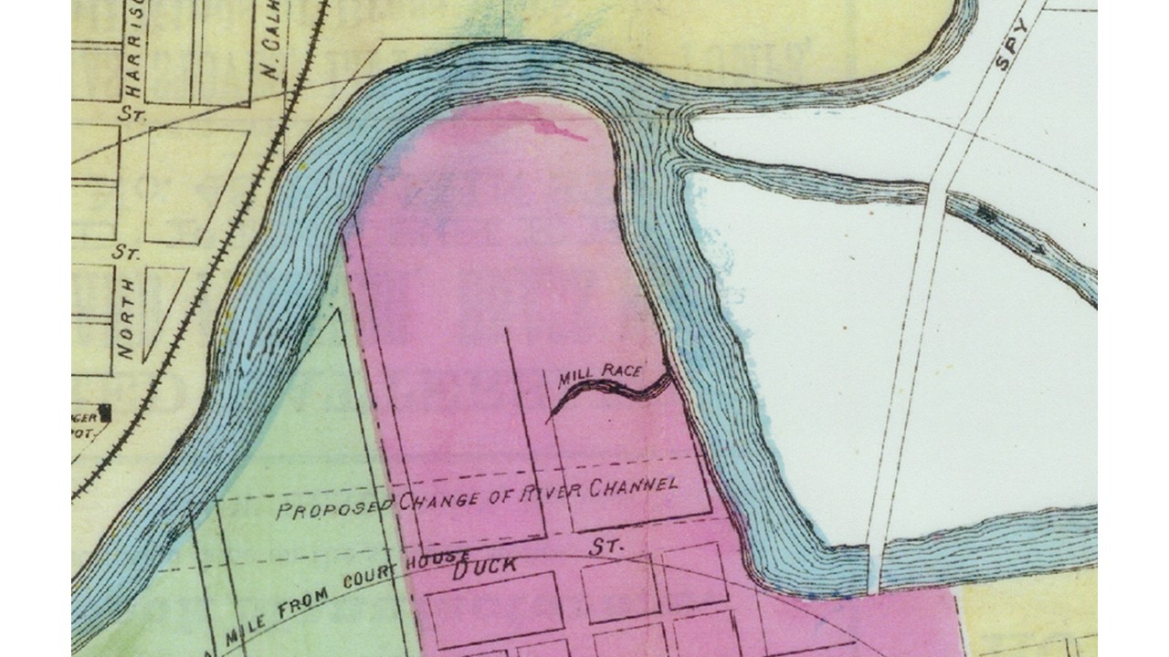
Many years ago a plan to straighten the St. Mary's river, north of Calhoun street, was talked about and the project has again come up for discussion. At the next meeting of the common council the following petition will be presented for consideration "The undersigned, your petitioners respectfully petition your honorable body to straighten the St. Mary's river from Wells street bridge, thence following nearly as can be the south bank and in direct easterly course below the county jail property to a point where the same would intersect the river above Spy Run avenue bridge. Your petitioners believe that if your honorable body would cause an excavation sufficient for a water course of the St. Mary's river at that point, would be of great public benefit and utility, that it would reclaim a large tract of land which now at times is overflowed and would materially improve that portion of the city of Fort Wayne. We urgently request that immediate steps be taken toward said improvement at this time, because it would give employment to hundreds of men who are now out of employment, and thus relieve a great amount of distress. In view of all these facts, your petitioners pray that immediate steps be taken to straighten the channel of the river, and for which we will ever pray."
The following petition which has been quite generally signed, will be presented to the city council next Tuesday night: The undersigned, your petitioners, respectfully petition your honorable body to straighten the St. Mary's river from Wells street bridge, thence following nearly as can south and in a direct easterly course below the county jail property to a point where the same would intersect the river above Spy Run avenue bridge. Your petitioners believe that if honorable body would cause an your excavation sufficient for a water course of the St. Mary's river at that point, it would be a great public benefit and utility, that it would reclaim a large tract of land which now at times is overflowed and would materially improve that portion of the city of Fort Wayne. We urgently request that immediate steps be taken toward said improvement at this time, because it would give employment to hundreds of men who are now out of employment, and relieve great amount of distress. In view of all that these facts, your petioners pray immediate steps taken to straighten the channel of the river, for which we will ever pray."
The estimated cost of the work is $50,000. The improvement is one that has been under consideration for several years and it has many advocates.
COUNCILMAN LANGARD HAS PLAN TO REDEEM BOTTOM LANDS.
Cut New Channel for the Stream Across the Flats to the Foot of Barr Street--To Join Spy Run a and Bloomingdale for Fire. Proteotion.
A plan to straighten the channel of the St. Mary's river through the central part of the city will be proposed to the county commissioners by Councilman Louis Langoad and others before the work of constructing the new Clinton street bridge is begun. The matter was brought up informally by Mr. Langard after the counall meeting last evening, and a number of the city officials present took favorable view of the project. It has long been thought that the long bend from Wells street to Barr should away with, but the matter was never taken up officlally. If Mr. Langard's scheme is indorsed it will mark a vast improvement in that part of the city.
The bottom lands comprising the peninsula by the bend are located so close to the business center that they should be built up, but the annual overflows to the river's course make it practically waste territory. If the river were diverted by means of a channel cut straight across from the foot of Harrison street to the foot of Barr street the earth taken out could be used to fill up the old channel and the surrounding low 1and as well, and it would not be long until the entire district north of the river would be built up. The city's future market space lies right in this territory and the surrounding land would be valuable for business purposes.
THE NORTH SIDERS WOULD STRAIGHTEN ST. MARY'S RIVER
The North Side Civic Improvement association will meet at the usual place on Wednesday evening of this week to receive the reports of the various committees appointed to further the work of civic Improvement for north side The main topic for discussion will undoubtedly be the proposed work of straightening the St. Mary's river through the Guldlin playground, as the residents of the north side and the Barthold street bridge committee are working hard to have this carried through successfully.
Council Will Turn Down Flat Proposition to Straighten the St. Mary's River.
As a result of the decision of the council committee of the whole to report back to the council at the next meeting recommending that the proposal to straighten the St. Mary's river at Barthold street be tabled, it is generally accepted today about the city building that the Harrison street bridge will be built before the Barthold street structure is erected. The board of works has confirmed the resolution for the opening of a street from the south bank of the river south across the Guldlin playgrounds to Michaels avenue, but the assessment roll has not been confirmed as yet and will not be until after action is taken on the Harrison street rolls.
"The defeat of the project to straighten the St. Mary's river at Barthold street should not be taken to mean that improvement never will be put through," Mr. Lennon said today. few years now I believe that the public will come to realize the necessity for through thoroughfares and that then the scheme to a open Broadway and thus afford a real approach to the proposed Barthold street bridge over the river will not appear so wild and impossible as it may at present.
NAME COMMITTEE | TO TAKE CHARGE Permanent Body to Deal With Flood Prevention Situation. CLINE PROMISES AID
Mr. Taylor Talks.
Frank B. Taylor delivered a brief address and suggested a plan for eliminating some of the trouble here.
"I agree with Mr. McCulloch," continued Mr. Taylor. "The dikes should be built higher and wider, and the bridges should be constructed wider. Raising the bridges would not do any good but in saving the bridges themselves. They should be made wider.
"The river channel at the entrance to Lakeside should be widened also, and before this is done the channel of the St. Mary's running through Fort Wayne should be straightened."
"To control the situation in Lakeside it will necessary to build a higher dike, straighten the St. Mary's river and widen the Maumee. The bridges constricted the situation at the junction of the three rivers, and I believe everybody agrees with me. We talk of beautification, but let us, improve them so they will protect us and then beautify them afterward."
Following the address of Congressman Cline, Mr. Breen called on Frank B. Taylor. His remarks were brief and to the point.
"My father's acquaintance with geographical and topographical problems has greatly aided me in my work. Of course, as I am a geologist, I think perhaps it is a mistake for me to be classed with the big army engineers who have had years of experience. There are two classes of difficulties that precipitate floods.
"One is the natural conditions, which we always have to fight, as for instance where the St. Mary's and the St. Joe rivers unite, to form the Maumee. I think it would be a wise plan to change this situation and make the St. Mary's farther from the bends. The present condition is bad for floods.
"A passage from the St. Mary's river through the Trier ditch to New Haven and there connecting with the Maumee might be the means of remedying conditions in Fort Wayne or better still to form a channel with the Little river and on to the Wabash river at Huntington. There will also be some advantage by deepening the lines of diverted overflow.
"Another thing: What man has done here. From Walton avenue to Broadway, not counting the foot bridges, there are fourteen bridges. None of them has been built with the wisdom that should have been exercised. On the south end of Broadway bridge the water was even with the top of the stone, while on the north side it was five inches lower. If the bridges had been built right this condition of affairs would not exist.
"To control the situation in Lakeside it will be necessary to build a higher dike, straighten the St. Mary's river and widen the Maumee. The bridges constricted the situation at the junction of the three rivers, and I believe everybody agrees with me. We talk of river beautification, but let us improve them so they will protect us then beautify them afterward."
Mr. McCulloch's Suggestions.
"Raise all the iron bridges in the city three feet." spoke up Charles H. McCulloch, "start to dredge the rivers, pile the dirt up three feet higher on the Maumee dike and five feet higher on the St. Joe dike, straighten the St. Mary's river, start the work at once and let the county and city vote a $500,000 with which to do It.
"But the best thing to do now would be to put dynamite under the Tennessee avenue and Coombs street bridges and blow them up," This statement brought cheers.
Citizens Met Last Night to Consider It from All Angles.
HOSEY GIVES HIS VIEWS
Few big public improvement projects in the history of Fort Wayne have met with such widespread interest as that which attracted a large crowd to a mass meeting at the Nebraska school last night. The details of the plan to enlarge Swinney park by the acquirement of the Cressler, Randall, Wilkins and Lennon tracts, the placing of a bridge across the St. Mary's river and the establishment of direct connections which would eliminate end streets and open a large tract to the west for settlement and development, were fully discussed and certain misunderstandings cleaned away.
Many who the meeting are employed in the Nickel Plate shops, the Wayne Knitting mills, the Eckart Packing company, the Horton Manufacturing company and other west side shops. The proposition to straighten the St. Mary's river by cutting a channel Swinney. park occupied attentioh and this raised the question of the ownership of the streams within city.
Max R. Miller, president of the West Side Improvement association, occupied the chair and directed the discussions. Mayor W. J. Hosey, responding to an invitation of the chairman, stated that but a few years ago the taxpayers objected strongly to improvements such as asphalt streets; now a public sentiment has changed to such a degree that the demand for improvements of this order is ofttimes greater than can be met by the city. The mayor, in referring 'to the proposed west side improvement, pointed out some of the difficulties to be encountered along with the great benefits to be derived therefrom. He pointed out the fact that a positive public sentiment must be back of a project of this magnitude. Referring to the advantages of the plan, the mayor pointed out the fact that there is no bridge across the St. Mary's river between Main street and Taylor street, and that a bridge spanning the river at Swinney park would open a new and direct connection to the west.
Explaining the failure to create a flood commission for Fort Wayne under the new law, the mayor stated that the required, proportion of citizens have failed to sign the necessary petitions asking for the creation of the flood commission.
He advised the citizens of the west side to discuss the proposed inprovement in all its phases in an impartial way. Carl J. Getz, city forester, representing the park board, answered many questions concerning the project and the entire evening proved to be one of enlightenment and enthusiasm. The features of a new map of the proposed improvement, were explained byB. J. Griswold, chairman of the. publicity committee of the west side association.