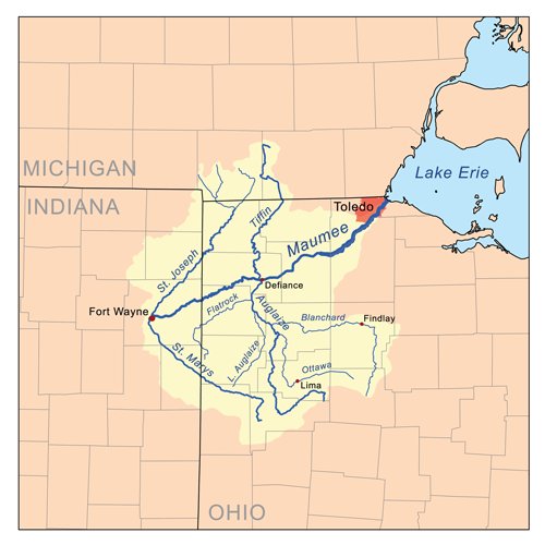
With the largest watershed of any Great Lakes river (8,316 square miles), the Maumee officially begins at the confluence of the St. Joseph and St. Mary’s rivers in Fort Wayne, Indiana, draining all or part of 17 Ohio counties, two counties in Michigan, and five more in Indiana. That’s a lot of river to roam. From Maumee River Ripe for Rediscovery on American Rivers.
The Indians, perhaps for centuries, had been accustomed to look to the streams here for much of their food in the form of fish, so abundant were they from Lake Erie to this point, and for some distance up the St. Mary's and St. Joseph. During seasons of freshets, in great quantities, and some of them very large, they would find their way up the Maumee from the lake, and when the high water subsided, they were often so numerous, that it was difficult to ride a horse or drive a team across the streams here without the animals or the wheels of the vehicles running over some of the finny tribe ; and some years ago, a company from Cincinnati began, and for several years carried on, the manufacture of oil from the fish caught here. Many boys and Indians made very good wages by catching the fish for the company. The Indians had always been of the belief that the Great Spirit had thus filled these streams with fish for tlieir special benefit, and when, a few years subsequent to the period in question, a dam was built near the mouth ot the Maumee, at the Lake, and the fish prevented from getting into this stream, as their number gradually diminished, and the company compelled to cease its operations thereby, the Indians expressed great displeasure, and considered it a direct encroachment upon their rights, and the designs of the Great Spirit. from page 295 titled Great Quantities of Fish in the Maumee in the book History of Allen County, Indiana, Publication date 1880, Publisher Kingman Brothers on Archive.org.
An Intercepting Under Ground Canal Necessary to Preserve Our Health.
THE PLAN IS PROPOSED.
Mammoth Sewer From West Superior Street to a Point Down the Maumee.
IT WAS DISCUSSED YEARS AGO.
A Quarter of a Century Age Engineer Jobs Ryall Said That City Must Have Sewer.
This morning Mr. McCracken, of board of public works, stated to the News that it will be absolutely necessary for the city to have a long intercepting sewer built from one end of the city to the other to obviate the necessity of dumping all the city's sewage into the rivers in the very heart of the city. If the South Wayne sewage is dumped into St. Mary's river west of the city and permitted to flow through the very heart of the municipality, it will make of the St. Mary's river and the Maumee river an open sewer, especially, in the summer time. when there is scarcely a sufficient amount of water in the rivers to make them flowing streams.
The only way which this trouble can be averted and preserve the health of the city will be to build a long intercepting sewer from one end of the city to the other. Twenty years ago John Ryall, then city engineer, advised the citizens to prepare to build an intercepting sewer from the western end of Wayne street near the fair grounds to the extreme eastern end of the city down Wayne street, with a terminal for the sewer in the Maumee river near the Fall's slaughter house. Since then an asphalt pavement has been down over part of Wayne street and put brick pavement over the eastern end. This will greatly interfere with building a deep tunnel sewer on that thoroughfare. Mr. McCracken now suggests to the News that in his opinion the city will be obliged some day to build an intercepting sewer from the western end of street near the Orff mill, down Superior street to a point near Spy Run Superior and thence to the Nickel Plate avenue right of way. The intercepting sewer could then follow a course along or near this right of way to a point some distance beyond Glasgow avenue and finally empty into the Maumee river. This intercepting must of necessity be slightly lower than the other sewers, and they must empty into this sewer. With the South Wayne sewer confronting the taxpayers, this intercepting sewer seems to be almost a necessity at present. City Engineer Randall is in favor of this plan, and has already discussed the matter.
Out of this aroused public spirit might come the execution of the plans for the solution of Fort Wayne's sewer-river-flood problem (and it is one problem, not three) and thus guarantee the suburban districts of Lakeside, Spy Run, Bloomingdale and Nebraska against a repetition of the flood of 1913: give Fort Wayne a sewer system in keeping with her needs and her growing population and restore our three rivers to their original beauty and usefulness.
Our historian of "Harmar's Defeat," in speaking of these rivers, says, "The river," (referring to the Maumee river at Harmar's Ford, as it was called before Hamar's defeat, the common fording place') "is about seventy yards wide- -a fine transparent stream. The river St. Joseph is about twenty yards wide (low stage of water) and, when the waters are high, navigable a great way up it." Mark the difference between then and now. Under the then rule of the uncouth and the savage Indian, the Maumee was a fine and and transparent stream; under the rule of the civilized and cultured white man, the Maúmee river is today an open sewer.
In this series of articles quoting the "summary" of the Fort. Wayne "Report upon improvement of rivers and sewerage system," we have reached that part the of the "summary" which deals with the present and future trunk sewer system of the city.
The authors of that report, Metcalf and Eddy, estimated the area and population of Fort Wayne as of 1950 and then, in their report, extended the present sewer system to provide for a city of the assumed area and population.
At the time the report was being prepared, in 1910, the area of Fort Wayne, exclusive of rivers, was 8.6 aquare miles; the average density of population WAS 11.6 persons per acre, and the population was 63,933. The report assumes that in 1950 the area will be 17.3 square miles;. the average density of population 13.6 persons per acre, the population 150,000.
As shown in previous articles, Fort Wayne has grown, and is now growIng faster than Metcalf and Eddy, in 1911, estimated it would grow.
The report contains a large map of the city; and on this map, sewer districts numbering from one to 47 are outlined; and the present, and proposed trunk sewer system each of these districts is shown.
The "summary" of this report outlines both the present and the proposed sewerage system of each of these districts. But this part of the "summary" is long and, therefore we think, best to give only a synopsis of it. Enough, however to give the reader a general idea of the sewerage problem confronting Fort Wayne. The reader should Keep in mind the fact that considerable sewerage work has been done in Fort Wayne since this report was published.
Maumee River (City Plan Commission 1963), by City Plan Commission (Fort Wayne, Ind.), August 1963, Description: There are 17 maps one of which is a Key. Then there are two maps per each section of the river. One map describes landownership along the river, types of river debris and/or storm drains and the like, and historical sites. The other corresponding section map describes the river level at designated measuring stations.
The Maumee River Basin is the largest watershed in the Great Lakes region, collecting runoff from more than 6,600 square miles in Indiana, Ohio, and Michigan and depositing it in Lake Erie—though as the lake’s largest tributary the river’s influence is not entirely positive. In this lively, ruminative book, Ryan Schnurr explores the history, ecology, and culture of the Maumee River, from the influence of glaciers, through its role in Native American and American history, to contemporary environmental issues. Part cultural history, part nature writing, part personal narrative, In the Watershed is a lyrical work of nonfiction in the vein of John McPhee and Ian Frazier with a timely and important message at the core. (From the jacket copy.)
Few have probably heard of the Bullerman Ditch, which has its origins near the corner of Lahmeyer and Stellhorn roads in northeast Fort Wayne. From there, it winds south for about 3 miles through urbanized development and a bit of agricultural land before it drains into the Maumee River at North River Road. "As tributaries go," said Matt Jones, water resource education specialist for the Allen County Partnership for Water Quality, "it may seem like it’s just a drop in the bucket, but indeed, it runs through the most intensely landscaped countryside as it makes its way to the Maumee." With a conference on an Upper Maumee Watershed environmental implementation plan scheduled for Jan. 24, Save Maumee Grassroots Organization’s founder Abigail King has initiated a campaign to highlight the importance of the Bullerman Ditch. Copied from a longer article Save Maumee campaigns for clean ditch by Jamie Duffy published March 16, 2016 in The Journal Gazette newspaper.
Highlights of the Maumee River Valley Did you know… The Maumee River is the largest in the entire Great Lakes System, unique geography of the Maumee watershed is a remnant of glaciers and the slowly falling water levels of prehistoric Lake Erie, served as a link between the Mississippi River system and the Great Lakes for humans for over 10,000 years, Britain and France vied for dominance in trade with Native American communities, and it was a major theater during the era between the French and Indian War and the War of 1812, France built two forts in the valley–Fort St. Phillipe des Miamis and Fort Miamis– near what is now downtown Fort Wayne, between 1700 and 1750 - read more from Maumee Valley Heritage Corridor.
St Marys and Maumee at Indiana Department of Natural Resources. The St. Marys River and Maumee River Watershed is located in northeastern Indiana, draining approximately 376 square miles in Adams and Allen counties. Major streams included in the Total Maximum Daily Load (TMDL) report are St. Marys River, Maumee River, Habegger Ditch, Gates Ditch, Blue Creek, Yellow Creek, Martz Ditch, Borum Run, Holthouse Ditch, Kohne Ditch, Gerke Ditch, and Nickelsen Creek, Trier Ditch, Bullerman Ditch, Gar Creek, Botern Ditch, Black Creek, Ham Interceptor Ditch and other tributaries.
Did you know that most of Allen County is a part of the Maumee River Watershed? A watershed is an area of land that drains water into a particular water
Chef sculpture w/ a lil chicken-shovel friend beside him, thanks TekVenture for the makerspace that enabled me to build...
Chef sculpture w/ a lil chicken-shovel friend beside him, thanks TekVenture for the makerspace that enabled me to build and assemble this!!! All made from scrap metal pulled out of the maumee river! Donated to the Save Maumee Grassroots Organization
January Ice on the Maumee River ❄ Did you know ice cover is important and beneficial to our rivers? Ice cover during the winter months reduces flow, decreases turbidity, and limits nutrient mixing. This can help reduce river bank erosion and even increase the walleye 🐟 population. Less sediment in the river during the spring time walleye run can lead to a more successful hatch. When walleye lay their eggs on the gravel bed in the river, the eggs can become suffocated if there's too much sediment. Less sediment= more successful spawn! The spring time ice break on the Maumee River is a force to be reckoned with! It can be incredible, dangerous, and breath taking. It also plays a major role in keeping river and streamside habitats healthy. Learn more about the Maumee at ohiodnr.gov/scenicrivers. #OHScenicRivers #ohiotheheartofitall #wintervibes
Did you know ice cover is important and beneficial to our rivers? Ice cover during the winter months reduces flow, decreases turbidity, and limits nutrient mixing. This can help reduce river bank erosion and even increase the walleye 🐟 population. Less sediment in the river during the spring time walleye run can lead to a more successful hatch. When walleye lay their eggs on the gravel bed in the river, the eggs can become suffocated if there's too much sediment. Less sediment= more successful spawn!
The spring time ice break on the Maumee River is a force to be reckoned with! It can be incredible, dangerous, and breath taking. It also plays a major role in keeping river and streamside habitats healthy.