Fort Wayne’s Civic Awakening The Preservation and Improvement of Natural Beauty in a City That Has Eighteen Miles of River Front 715. By Charles J. Steiss, Secretary Board of Park Commissioners, Fort Wayne, Ind.
FISHING IN THE MAUMEE, THE SUNFLOWER CLUB, ST JOE THE FISHERMAN, THE - OLD CANAL
What is Fort Wayne's very best little summer resort?
Fling that question into the city streets and the responses will be as various as favorite movie stars.
Messrs. Williams (Manager and Henry M.) shout Lake Everett and Robison park in gentlemanly discord, Rome City is proclaimed by its thousands, and Clear lake, Lake James, Wawasee, the Michigan resorts and the mountains and the seacoast all have their admirers.
But of Fort Wayne's 83,251 inhabitants, just about eighty thousand spend the summer in the same place. Fort Wayne is their summer resort.
Nor is it such a bad one at that. Of course there is no noticeably frigid weather here in July, there is no lake of any consequence to drown in, the river fish are not so hard to carry home--but anyway, it isn't so bad.
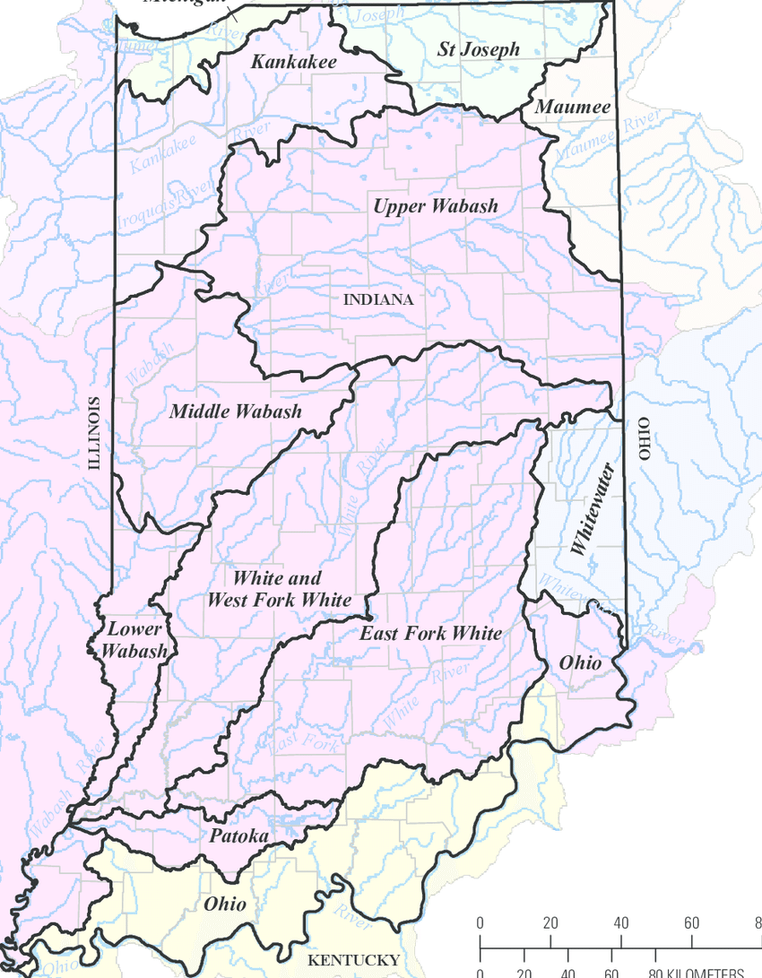
There are few inland cities so well located for summer living. Fort Wayne with its three rivers, with Spy Run creek, with a score of natural beauty spots, would make a summer resort the like of which northern Indiana and southern Michigan do not possess.
Some Take Advantage.
It is a very small per cent of the population of the city that takes advantage of the opportumties offered by the rivers. True, there are a good many Sunday picnies along the banks, but as to permanent cottages or even camps, they are very few.
The Sunflower club, a little yellow building on stilts on the south bank of the Maumee several miles below the city, is one of Fort Wayne's summer resort clubs. It stands in a grove almost on the river bank, and a little spring runs away to the east of it.
Although it still is boarded and shuttered, within a week or so it will open for the summer, and each Sunday till fall will see crowds of members and their families enjoying one of Allen county's beautiful river bank groves.
But the Sunflower club is not the only one of Fort Wayne's summer club houses, for there are a number up the St. Joe river. Above Robison park several miles, along the high east bank of the St. Joe river, are grouped a number-probably a half a dozen buildings. Several of them are club houses, and the others are the cottages of people who go up the river to fish, not only from Fort Wayne, but from other northern Indiana towns as well.
The river affords pleasure for two canoe clubs here, for at the park are two organizations, with a dozen or more canoes each, quartered in comfortable boat houses.
These canoe clubs have become very proficient in boat drills and their work on the river at the park has become a feature of the entertainment there.
The River Fishing.
But the vast majority of the persons who enjoy the rivers own no cottages nor do they belong to the scattered river clubs. They are the fishermen and picnickers who every day line the banks of the river not only in the country near the city, but here within the city limits as well. One standing on the Lakeside bridge Satuday morning and looking north, would have seen the Lakeside bank with a dozen fishermen scattered along it, and two men in a pair of greenish gray boats paddling up the St. Joe. Sitting boats, now famous Foster piling gray along the St. Mary's, two or three boys cool their heels and ankles, and at the junction of the rivers a group of swimers spoiled whatever chances the fishermen had anticipated.
All the way up the river fishermen are found and when one passes the city limits signs of camp fires are frequent. It is up the St. Mary's and St. Joe the real fishermen go, several miles about the city, there to spend the week-end in studious contemplation of the forces of nature and the scarcity of bass.
True, some men seem to be born with silver trolling spoons in their mouths, for one will see them come in from the Maumee, or either of the other rivers with regular strings of regular fish. For verification of this statement stand any morning at Columbia and Barr and watch Officer Harry Birely tug a string homeward.
One morning last week fifteen boys sat on fifteen of bank on Spy Run creek, and fished for the little sunfish that every now and then came up after hundred feet below the Lawton park after then hooks.
Each Sunday, too, finds the river banks in the parks crowded with picnickers, and it is estimated that in the course of a Sunday twenty thousand people visit local parks in the summer.
The Simming Hole
Fort Wayne, may she have everything else except the puces and mosquitoes make perfectly good summering place, sadly lacks swimming pools. Do you realize that in all Fort Wayne there is not single public swimming pool. There is a small pool in a local bath house, but it is not large enough to deserve the name.
The city officials on Friday afternoon Wayne's went over the of the proposed swimming pool in Spy Run creek, and decided that the dam be built several hundred feet below the Lawton park bridge. This will give a pool of considerable lenght and depthn, and for the first time Fort Wayne will have an opportunity to go swimming right.
Of course there is swimming in the old canal be and each day in summer scores of boys walk a mile and half east of town to frolic in the 200 foot expanse of green water. The water isn't cooling, and it doesn't smell very encouraging even at a distance, and it's rather thick, but just the same it's wet.
So Fort Wayne is a summer resort after all. Swimming, canoeing, fishing, picnicking, fighting mosquitoes, they are all here, as a part and parcel of Fort Waynes, summer pleasure.
So what's the use of going to Newport this year and northern Michigan? Bah!
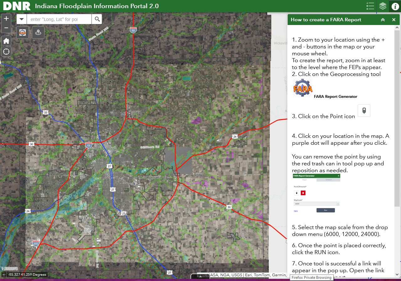
Knowing the floodplains in your area is crucial for flood preparedness. Floodplains are flat areas near water bodies prone to flooding. Consider elevating essential utilities like electrical panels and furnaces if you live in a floodplain. Always have a map with multiple evacuation routes and keep your preparedness kit ready. Stay informed about flood risks and plans. Remember, flood insurance policies take 30 days to become effective. The Indiana Department of Natural Resources Has a Floodplain Information Portal that includes both state and federal information. You can view that at Indiana Floodplain Information Portal. #FloodSafety#Preparedness
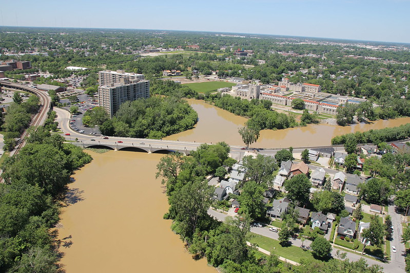
John McGauley photograph River Confluence taken June 3, 2013 posted on flickr An aerial view of the confluence of the St. Mary's, St. Joseph and Maume rivers in downtown Fort Wayne, Indiana.
Citizen River from Lynchpin Creative on Vimeo Filmed on location in Fort Wayne, Indiana on the St. Joseph River between Spy Run Avenue and Northside Drive.
Sponsored by Young Leaders of Northeast Indiana, Lincoln Financial Group. Original music by Alec Johnson.
One out of every five gallons of fresh surface water on the planet comes from the Great Lakes. On this...
One out of every five gallons of fresh surface water on the planet comes from the Great Lakes. On this #GreatLakesAwarenessDay, we celebrate the six quadrillion gallons of freshwater that make up the five Great Lakes. This precious resource supports rare and unique ecosystems—including freshwater coastal dunes, and rocky limestone flats called alvars—and more than 3,500 species of plants and animals. The Great Lakes truly are the #BestCoast!
A Watershed Mentality a WFWA TV39 PBS Fort Wayne Special | 27m 5s | Video has closed captioning. The Maumee River is the single largest tributary and watershed in the Great Lakes and deposits millions of cubic yards of sediment into Lake Erie yearly. Aired: 02/04/09 Rating: NR. DVD at the Allen County Public Library.
#FishingFriday: Meet Mike! Mike is a local competitive fisherman who helped to found Indiana Kayak Anglers! Did you know...
#FishingFriday: Meet Mike! Mike is a local competitive fisherman who helped to found Indiana Kayak Anglers! Did you know that Kayak Fishing is the fastest growing sport within the fishing arena? Mike catches (and releases) incredible species right here on our Fort Wayne rivers! Here's Mike this past summer with a Northern Pike. Thanks Mike and all of the local Kayak Anglers for being such huge advocates for our rivers!
In Fort Wayne, the rivers were a vital component to the establishment of settlements and life in Allen County. Since...
In Fort Wayne, the rivers were a vital component to the establishment of settlements and life in Allen County. Since 2005, World Rivers Day, a day to celebrate the world’s waterways, has been observed on the last Sunday of September. It highlights the many values of our rivers, strives to increase public awareness, and encourages improved stewardship of all rivers around the world. September 2019 marks the first year of Fort Wayne's involvement in this worldwide celebration of our rivers and the drive to protect them. Come to Fort Wayne’s celebration and stop by the History Center’s table to learn more about our community’s river heritage! #sociallyhistory
World Rivers Day
Promenade Park
Sunday, Sept. 29th
2-5 PM, Free Admission
IMAGES
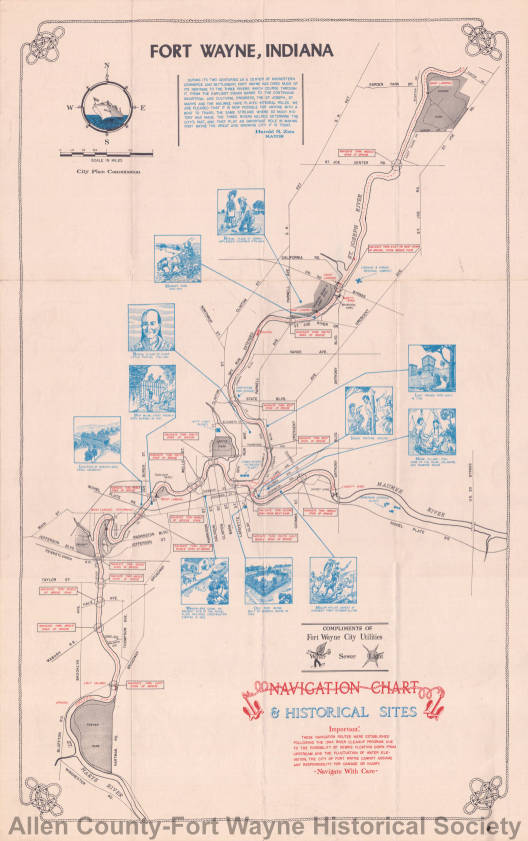
Etching by George Gawehn.
Painting: showing the original State St Bridge was iron and was replaced by a concrete bridge in 1919. The Rudisill dam and mill are depicted as well as the brewery.
Cattle in a river
3 people in canoe
Friends of the Rivers armband
This video shows a modern look at how it would be possible to travel by river from Fort Wayne to the Gulf of Mexico.
Fort Wayne to Gulf of Mexico via river May 2, 2023 Scharpy1 on YouTube.
My first attempt at Google Earth tour recording. Wondered if it would be possible to float all the way to the Gulf of Mexico from close to home. Yes, it would. Start at Little River, 900 feet west of Ardmore Avenue next to Hardrock Road. Here's the kicker...go 1600 feet east of that point to float to the Atlantic Ocean via Fairfield Ditch, St. Marys River, Maumee River, Lake Erie, Niagra River, Lake Ontario, St. Lawrence River, Atlantic Ocean. Hence Fort Wayne's nickname: The Summit City, the high point of the Wabash and Erie Canal.
If a chemical spill were to happen on the St. Joseph River, City Utilities would take proper action while working with the U.S. Department of Homeland Security, the Indiana Department of Environmental Health and the Allen County Department of Health.
City Utilities said the delivery of safe, abundant, high-quality water to customers is an ongoing priority.
“To that end, Three Rivers Filtration Plant conducts more than 50,000 tests daily in our lab and through our automation processes,” the statement said. “Our water testing occurs every minute of every day.”
A long post but PLEASE be engaged and SHARE SHARE SHARE! Even if you don’t live in the Northside Neighborhood, this issue could affect the future of our rivers.
Dear Neighbors, this may very well be a moment in time when the actions of a few determine a dramatic change in the character of our Northside Neighborhood.
The Allen County Plan Commission recently passed the request for zoning change (from residential to commercial) and the preliminary site plan for the property at Spy Run Ext. and Parnell. This request for a party boat “headquarters,” while not officially in the Northside Neighborhood could have a big effect on the quiet, family-friendly area that we all love.
The board of the NNA has written letters, passed petitions, communicated with neighbors and city leaders, spoken at the plan commission hearing, etc. The next step in the process is for Fort Wayne City Council to vote on the recommendation to approve the zoning change and preliminary site plan. This is where we can put a stop to the plan. WE NEED YOU!
While our city council representative, Russ Jehl, has communicated his intention to support the desires of his constituency and vote, “no,” his is only one vote. PLEASE contact the other members of city council and ask the to also vote, “NO!” We’re including here a list of email addresses (you can cut and paste), but it will also be helpful for you to CALL!
We’re adding some of the points that are helpful in making our case that the location of this party-based business is BAD for the Northside Neighborhood.
We in the Northside Neighborhood LOVE our rivers. We ARE the “river neighborhood,” bordered on three sides by the rivers. We LOVE encouraging people to enjoy this naturally beautiful asset of our city! We LOVE riverfront development that ADDS to the quality of life here in the Northside. This development will DE
TRACT from those of us who live closest to the rivers.
Here are some points to make when contacting our city council members (all of them!). It’s also helpful to copy Mr. Jehl on your communications and thank him for supporting the Northside Neighborhood.
1) Increased traffic and overflow parking in the Northside Neighborhood.
2) Increased automobile traffic around the trail system in the Spy Run/Parnell area, disturbing and making unsafe its use by pedestrians and cyclists. Moving the trail to streetside and along the parking lot is not comparable nor an acceptable solution that is fair to the taxpayers and users of the trail system.
3) Increased noise from the large number of partyers on the river at once, disturbing and making unsafe the quiet riparian environment currently enjoyed by kayakers and others paddlers.
4) Concerns about increased incidences of public intoxication and driving under the influence in the neighborhood.
5) Increased traffic in an already congested area.
(And the following statements are regarding the Fort Wayne Allen County Comprehensive Plan, ways in which the proposal contradicts the plan which was adopted by the city as a guiding document.)
6) This proposal is not compatible with surrounding development which is predominately Residential Zoning and Residential Land Use.
7) This proposal will negatively impact nearby property values by removing natural elements that draw homeowners. It will also negatively impact property values by situating an adult outdoor business near residential neighborhoods. It will be injurious to the morals of the families living in the surrounding homes.
This proposal will be injurious to public safety and general welfare by removing the beneficial features of the existing property, which are many.
The Maumee Torrent, also known as the Maumee Megaflood, was a catastrophic draining of Lake Maumee, the ancestor of present-day Lake Erie, that occurred approximately 14,000[1] to 17,000 years ago[2] during the late Wisconsin glaciation. It happened when the waters of Lake Maumee, possibly in response to an advance of the ice front at the eastern end of the lake, overtopped a "sag" or low spot in the Fort Wayne Moraine, which was a deposit of glacial debris that acted as a natural dam at the site of present-day Fort Wayne, Indiana. This unleashed a massive flow of water that scoured a one- to two-mile-wide outlet running southwest to the Wabash River known as the "Wabash-Erie Channel", which probably followed the course of earlier, less massive drainage. The channel, now a small stream called the Little River, is the largest topographical feature in Allen County, Indiana. As much as 30 feet of fine sand, silt and organic sediments were deposited in the channel before drainage reversed and was captured by the present-day Maumee River. U.S. Route 24 between Fort Wayne and Huntington follows the channel.[3]
Approximately 14,000 years before present, Lake Maumee overtopped the Fort Wayne Moraine. [1] The flood removed all earlier sediment and deepened the valley bottom by 20 feet (6.1 m).[1] Lake Maumee had reached 800 feet (240 m) above sea level when the lake poured through a sag in the Fort Wayne Moraine into the ancestral Little River and then the Wabash River. There is some evidence that the final rise in lake level that caused it to overtop the moraine was caused by a minor re-advance of the glacier further east in the basin.[1] The soft till of the moraine was quickly eroded by the volume of water in the lake, releasing a massive volume of water. A second outlet opened at Six-Mile Creek into the St. Marys River and into the Little River Valley. The earlier sediments were removed in bulk, leaving only the Sand Point and a few gravel terraces on the valley walls.[1] The flood scoured the length of the Wabash River. The limestone bedrock under the Little River Valley near Huntington created a sill, limiting the depth to which the Torrent and the future river could erode. The well-developed beach ridges in Ohio and eastern Allen County show a series of lower lake levels.[1]Copied January 2, 2024 from Maumee Torrent on Wikipedia, The Free Encyclopedia.
During some recent work at the Parnell Street bridge, our Riparian crew uncovered a plethora of bryozoans. What are they you ask? They are orbs or blobs that attach to woody debris in the rivers, but they are not toxic or poisonous and are harmless to touch. Bryozoans are a sign of clean water quality which is excellent news for the Saint Joseph River. Even further, they help clarify the water from sediment (which our rivers are full of), keep algal blooms at bay, and are great sources of food for fish and insects.