
The City of Fort Wayne in the Flood Control Department has a Chronological List of Floods back to January 1828. Also has a Contact Us - Flood Control page.
- From the former News-Sentinel Your Town. Your Voice. site archived back to December 2, 1998 on the Internet Archive Wayback Machine.
- Flood of the century (Elements in this Project) by The News-Sentinel newspaper was still onliine in April 2025 and archivedbut not the videos. YouTube video Flood Letter March 19, 2013. Betty Stein's account from the 1913 flood March 5, 2013; Has a clickable Before and After Map with 1913 photos and 2013 photos.
- Flood of the century: Part 1 by Cindy Larson on the Flood of 1913 references newspaper articles and couple of YouTube videos. Archived but not the videos. Now and then, the Flood of 1913 March 15, 2013.
- Flood of the century: Part 2 by Bob Caylor lists several floods with a couple of YouTube videos. Archived but not the YouTube videos. Headwaters Park March 5, 2013, Bob Kennedy on the latest flood-control improvements in Fort Wayne February 19, 2013. Incudes a slightly different version of the image FORT WAYNE BRIDGES. THE OLD AND NEW VAN BUREN STREET BRIDGE SPANNING THE ST. MARY'S RIVER IS LOCATED NEAR THE SOUTHERN EXTREMITY OF SHERMAN STREET at the Allen County Public Library Digital Collections at the Allen County Public Library.
- About The Flood Project is not online or archived!
- Photo Galleries is the News-Sentinel Flood of 1913 photos
- Who's behind the project on the Internet Archive Wayback Machine.
January 3, 2025 post on True Fort Wayne Indiana History on Facebook.

Flood of 1913 posted March 22, 2021 by Friends of the Rivers on YouTube. See our 1913 Flood page.
Flood & Erosion Control posted March 22, 2021 by Friends of the Rivers on YouTube.
The video mentions the major floods of 1876, 1913 [page 549 of Griswold's 1917 Pictorial History The Flood of March 1913 discussesd the 1876 flood and other earlier floods], and 1982. Then around the 25 second mark discusses moving the bodies and tombstones in Broadway Cemetery to Lindenwood Cemetery while showing the 1847 Ewing tombstone and other tombstones that were used to stablize the Saint Marys river bank in Swinney Park for flood control.
Fort Wayne Flood of 1982 posted March 22, 2021 by Friends of the Rivers on YouTube.
- See 1876 flood on Timeline, our 1913 Flood page, March 1978 on our Timeline page, and March 1982 flood page.
- AC Homeland Security @ACHomeland on X/Twitter reports current flooding in Allen County, Indiana.
- Flood Control Department and Chronological Flood History list at the City of Fort Wayne.
- Chapter XIV Fort Wayne, Indiana 24-page report at desastres.unanleon.edu.in. Appears to be a website based in India?
- WORKING PAPER #73 THE FORT WAYNE FLOOD: A CASE STUDY Brenda Phillips October 1984 University of Delaware Disaster Research Center.
- There are 28 mentions of flood in the book The pictorial history of Fort Wayne, Indiana : a review of two centuries of occupation of the region about the head of the Maumee River by Griswold, B. J. (Bert Joseph), 1873-1927; Taylor, Samuel R., Mrs, Publication date 1917 on Archive.org.
- 6. Description of the 1982 Flooding in Fort Wayne Indiana at Weather.gov with newspaper photos.
-
1985 Flood. Number 4 of the Five Worst Fort Wayne Floods. The Journal Gazette has at least eight 1985 Flood articles available to subscribers.
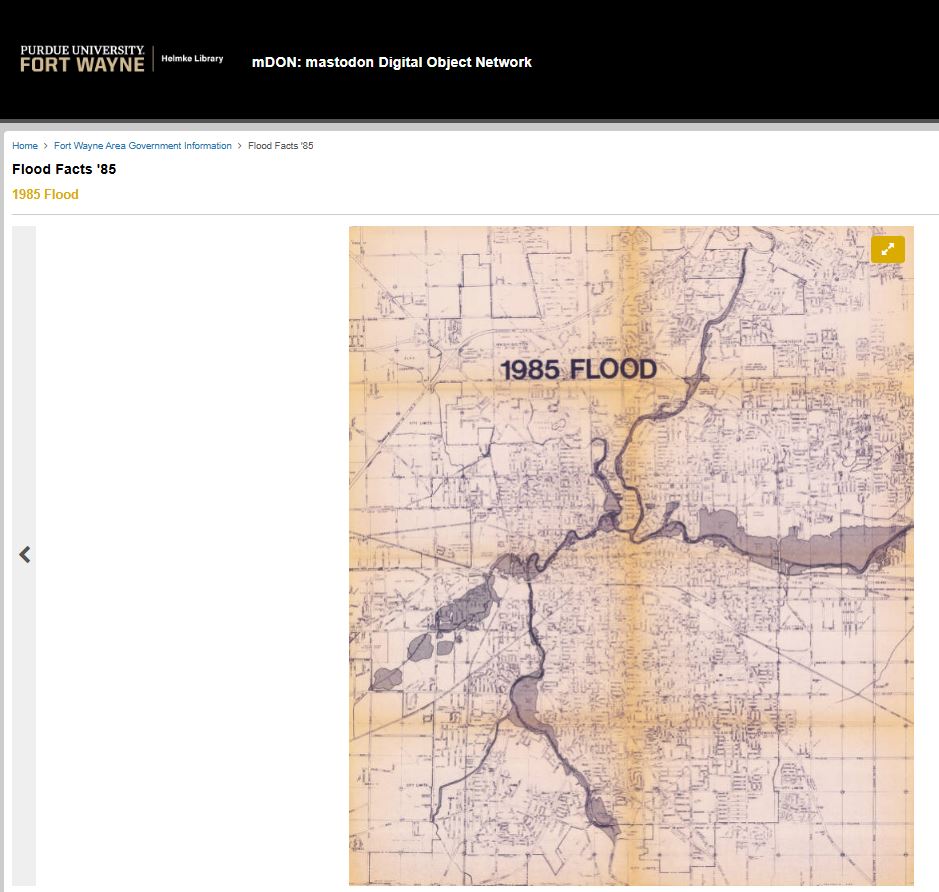
Flood Facts '85 at Purdue University Fort Wayne Helmke Library.mDON: mastodon Digital Object Network .
Appendix 7-C: February 1985 Fort Wayne Flood Summary, excerpts from a paper by Carrol, T.R. and R.D. Marshall, 1985. starting on page 125-130 of 230 pages, G-17 to G-22, lists Four Greatest Fort Wayne Floods 1913, 1978, 1982, 1985 in Federal Emergency Management Agency FEMA 116 February 1987 Reducing Loses in High Risk Flood Hazard Areas: A Guide for Local Officials.
Discussed April 6, 2025 on True Fort Wayne Indiana History on Facebook. March 8, 2022 post comments were mostly about the 1982 Flood.
-
1985 - Fort Wayne wants more flood control The Indianapolis News, Indianapolis, Indiana, Monday, February 25, 1985, Page 11.
1985 - Fort Wayne wants more flood control
Article from Feb 25, 1985 The Indianapolis News (Indianapolis, Indiana) 1985, Flood -
1985 - Floods from Midwest to New York have cost much money, some lives The Macon Telegraph, Macon, Georgia, Wednesday, February 27, 1985, Page 2.
1985 - Floods from Midwest to New York have cost much money, some lives
Article from Feb 27, 1985 The Macon Telegraph (Macon, Georgia) 1985, Flood - Page 42 Intensive Archaeological Survey for the Proposed Fort Wayne Flood Control Project at Fort Wayne, Allen County, Indiana Conducted for: U.S. Army Corps of Engineers - Detroit istrict Contract No. DACW35-88-D-0049 Delivery Order No. 0004 DTIC Selected Jan 30, 1990.CCRG Commonwealth Cultural Resources Group 6928.
In the mid-third of the survey area, the gravelly sand horizon interfaced with the humic top soil zone at depths ranging from 5 to 30 centimeters below the surface. This deposit, which is assumed to represent mixed river source fills, constituted the soil matrix associated with the cut limestone Rudisill Mill foundation which was identified in this area of CIO. Field examinations conducted on July 18, 20, and 26, 1989 provided data which indicate a high probability of survival of the above mentioned mill site.
- USGS Prepared in Cooperation with the City of Fort Wayne, Indiana Flood-Inundation Maps for the St. Marys River at Fort Wayne, Indiana Prepared in Cooperation with the City of Fort Wayne, Indiana Flood-Inundation Maps for the St. Marys River at Fort Wayne, Indiana By Chad D. Menke, Moon H. Kim, and Kathleen K. Fowler Pamphlet to accompany Scientific Investigations Map 3205 U.S. Department of the Interior U.S. Geological Survey U.S. Department of the Interior KEN SALAZAR, Secretary U.S. Geological Survey Marcia K. McNutt, Director U.S. Geological Survey, Reston, Virginia: 2012.
- A century's worth of work has made Fort Wayne less flood-prone City has tried three different types of flood-control approaches shows a timeline of floods and flood control projects over the past 100 years since the 1913 flood by Bob Caylor was published March 21, 2013 in the The News-Sentinel newspaper.
- Historic March floods of 1982 and 100th anniversary of March 26, 1913 flood that left 20% of the city homeless in The City That Saved Itself--TWICE! March 6, 2013 by Nancy McCammon-Hansen on History Center Notes & Queries blog.
- New house at 1523 Edgewater mentioned as being in the flood district in May 17, 1914 The Journal Gazette newspaper posted October 7, 2017 on the original Great Memories and History of Fort Wayne, Indiana page on Facebook
- Rivers On A Rampage - Recent Rains Cause Floods in all the Streams - St. Mary's and St. Joe Over Their Banks With Prospects for Record-Breaking Floods was the headline April 14, 1903 in the Fort Wayne News newspaper article April 14, 2014 discussion on the original Great Memories and History of Fort Wayne, Indiana page on Facebook.
- THIEME DRIVE: THE TRAGEDY OF THE CITY’S FLOOD PROTECTION PLANS posted March 5, 2007 on Berry Street Beacon blog.
- Where do floodwaters come from? This map shows you by Nexstar Media Wire, Jeremy Tanner posted: Aug 22, 2022, updated: Aug 22, 2022 on CBS WANE-TV NewsChannel 15.
-

FacebookMarch 5, 2023 post by Indiana Department of Natural Resources on Facebook:
Did you know Indiana has a flood insurance website where you can learn about flood risk, flood insurance, and mitigation activities? This site is joint project developed by the Indiana Department of Homeland Security, Indiana Department of Insurance and the Indiana Department of Natural Resources Division of Water. Check it out at IN.gov/floodinsurance.
-
Wednesday, April 3, 2024 post by WANE 15 on Facebook:
Fort Wayne’s rivers continue to have high waters as flooding impacts the safety of those on the water.
This type of danger, however, is something that Fort Wayne is used to.
Fort Wayne uses parks, city design to fight floods as high waters persist