3405 Lincoln Highway, New Haven at Fleetwood Avenue, Street View photo from Google Maps In the 1930s photo above the dirt street Fleetwood Avenue is almost not recognized as a street except there is an automoblile on either side of the main dirt road New Haven Avenue also part of the Lincoln Highway which was also dirt roads when it was first designated as a highway. The gray house on the right is the same unpainted house in the 1930s. The houses on the left in the 1930s have been removed in the current photo and are not found in online Google photos back to October 2007 either.
Indiana’s first stagecoach route was established along Buffalo Trace (Vincennes Trace) between New Albany and Vincennes in 1820. In the 1830s, the Michigan Road (U.S. 421), Indiana’s north-south connecting route between Madison (Ohio River) and Michigan City (Lake Michigan), and the east-west National Road (U.S. 40), America’s first federally funded road, were constructed. In 1913 the Lincoln Highway (U.S. 30) was dedicated, becoming America’s first transcontinental highway. Indiana’s first interstate, State Road 420 (I-80/I-94) opened in 1952. A few years later the Federal-Aid Highway Act of 1956 created a national interstate highway system, leading to the construction of interstates such as I-74, I-465, I-65, and I-70. By this year, 97% of Hoosier households owned at least one automobile. Copied from a July 27, 2022 post by Indiana Department of Natural Resources on Facebook. Included images of the 1920 Map of Indiana showing state highways and 1968-1969 Indiana state highway system at Indiana Memory Hosted Digital Collections at IN.gov.
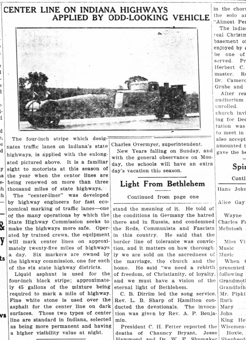
Our Highway Commission collection keeps surprising us with interesting finds!
These photographs display what's possibly a road painter vehicle from the 1930s.
A comment to the original post included a newspaper article showing this vehicle: Painting the center lines on Indiana's highways from The Waterloo Press, Waterloo, Indiana, Thursday, Dec 22, 1938, Page 8
Since early 19th century Indiana state law required males aged 18 to 50 to open and maintain public roads, it follows they would claim the road as theirs by naming it after their family labor which is why many local roads are named after the pioneer families that first settled on land bought from the United States government.
A law of 1816-17 required males age 18-50 to donate up to 6 days labor annually to open and maintain public roads. The federal government built the National Road in Indiana from 1829 to 1834. It is now U.S. 40. The Internal Improvements Act of 1836 was the state's over-ambitious attempt to address transportation needs of Hoosiers, especially for commerce and trade. Eight major projects were specified. The law resulted in financial disaster, and construction was stopped in 1839. Many projects were later completed with public and private funding. Indiana, Crossroads of America, has thirteen interstate highways--more than any other state--with a total of 1,138 miles. Copied from the Transportation page at Introducing Indiana-Past and Presentwebpage, and Introducing Indiana-Past and Present pdf both at IN.gov.
Traveling around Allen County and Northeastern Indiana in the early 19th century was difficult. One of the major reasons was that our portion of the state was at the western edge of the Great Black Swamp, which made roads virtually impassable. One of the solutions was the construction of plank roads. In 1847, the Fort Wayne and Lima Plank Road Company, headed by Samuel Hanna, developed Lima Road into the first plank road in northern Indiana. A plank road is constructed of a series of wooden planks laid next to each other, providing a surface over which wagons could travel in all weather conditions. When it was completed, the Lima Plank Road reached Sturgis, Michigan, a distance of 60 miles. The planks for the road were three inches thick and eight feet long. These pieces of oak are from a plank on the original Lima Plank Road, which went from Fort Wayne to Lima, now Howe, Indiana in LaGrange County. The oak plank was excavated north of LaOtto during road construction. #sociallyhistory
Our crews work hard to take care of our roads and fix things when problems come up. Here's a close up look at crews spot paving on U.S. 27 in Fort Wayne Wednesday. http://511in.org
Our crews work hard to take care of our roads and fix things when problems come up. Here's a close up look at crews spot paving on U.S. 27 in Fort Wayne Wednesday. http://511in.org
Hoosier motorists had hopes for easier traveling on this day in 1919. The newly organized state highway commission was...
Hoosier motorists had hopes for easier traveling on this day in 1919 [July 27]. The newly organized state highway commission [INDOT] was busy laying out our present system of state highways. At the time, only a few stretches of highways were paved. Most were covered with gravel or crushed stone. The commission also began numbering highway routes. You had to look quickly to see if you were on the right road, though, as the route numbers were simply painted on white bands on telephone poles.
It's been called the most significant road in Indiana history. The National Road, which begins in Cumberland, Md., was a major route through the wilderness that thousands of early settlers used to reach Indiana. The pioneer road, which was completed in rough and rugged form through Indiana in 1834, bisects the Hoosier state east-west from Richmond to Terre Haute. Suggested by none other than George Washington, the National Road was the country's first federal highway project and initially ended in Vandalia, Il., an early state capital of Illinois. Other state capitals – including Indianapolis and Columbus, Ohio, were built on the National Road or in anticipation of its construction. The construction of the road was arduous, an aspect that Nelson will explore with his guest, Ball State University history professor Ron Morris, vice president of the Society of Indiana Pioneers. An expert on in-migration to Indiana, Ron has traveled extensively on the National Road. Beginning in the 1920s, much of the road was designated as U.S. 40, an era that Hoosier History Live explored during a show in 2013. For this show, we will focus on the earliest era of the road, particularly the challenges involved with its construction. During the pioneer era, workers were confronted by tall, towering trees, deep forests and meandering rivers and streams. Copied introduction to The National Road: pioneer highway into Indiana January 29, 2022 on the Archives of Hoosier History Live podcast on Saturdays, noon to 1 p.m. ET on WICR 88.7 FM.
Photograph showing a carriage stuck in the middle of an unpaved street. The description reads: "Eleven miles west of Zanesville, 1913, November." Beginning construction in 1806, the National Road (also known as the Cumberland Road) was the first federally-funded interstate highway. Crossing six states from Cumberland, Maryland, to Vandalia, Illinois, over 220 miles of the 600-mile road pass through Ohio. National Road in Zanesville photograph
FRIDAY FROM THE ROAD… Paving the National Road Congress authorized the construction of the National Road in 1806, with...
Congress authorized the construction of the National Road in 1806, with construction taking place between 1811 and 1834 to reach the western settlements. It was the first federally funded road in U.S. History. George Washington and Thomas Jefferson believed that a trans-Appalachian road was necessary for unifying the young country.
The National Road was built by rocks and gravel, broken by hand and laid in trenches. These trenches were twenty-feet wide with a 66-foot right-of-way. The road was built in layers of 12 – 8 inches deep, with larger stones on the bottom, smaller ones on top, with gravel and soil covering the surface. This method was devised by Scottish Engineer John Loudon Macadam and became known as “macadam roads”. This technique was considered the most advanced road construction at the time.
The brick and coal industries of Brazil, Indiana fueled much of the growth of the brick paving for roads. When brick became the preferred pavement, most of the bricks used to pave the National Road across Indiana were manufactured in Brazil, Indiana.
In the early 1910s and 20s, use of the National Road was rejuvenated by the growth and use of affordable automobiles, particularly the Ford Model T. Also, brick paving became popular. They were accessible, cheap, easy to install, and durable. While popular for early roads, bricks were replaced by concrete and asphalt in the l920’s & 1930’s.
There are parts of the US National Road where brick can still be found. In Indiana there was a section in Putnam County, but reports suggest this small section no longer exists.
Be sure to visit:
• Hancock County Historical Society, Greenfield, Indiana.
• Indiana National Road Association Interpretive Panel located in front of Clay County Historical Museum.