"Construction of Forts against Indians" Description: Anonymous author suggests the best type of fortification to defend against the Native Americans and describes a square or pentagon shaped fort with two-story blockhouses and a ditch around it. The author also considers making room for traders' houses and stores and suggests a location for ammunition storage. Date: [1785-1786?], Subject: Fortification--Northwest, Old Source Collection. Northwest Territory Collection, 1721-1825 at the Indiana Historical Society.
Born in Ashes: Indiana's Origins - Short Documentary about Indiana's Role in early U.S. History May 2, 2023 kennythenotsogreat on YouTube
While Indiana might not be the most well-known state today, it has played an integral role in the histories of both the (then) nascent United States and the various Native tribes that inhabited the region. What was referred to as the Northwestern Territory (Modern-day Midwestern U.S.) during the late 18th and early 19th century, would become the battleground of two major wars and Indiana would see a major part of those conflicts. Not only were there notable battles, but also exceptional people that took part on both sides of the conflict. From the Northwest Indian War to the War of 1812, Indiana's eventual statehood stemmed from these two conflicts, that finally paved the way for the United States to fully settle the Northwestern Territory. The Miami tribe, as well as other tribes such as the Shawnee, Lenape, Odawa, etc., would be either coerced or militarily forced to cede much of what used to be their lands and eventually be forced to move western across the Mississippi river. Find out in this short documentary about how all of this unfolded.
This production was possible due to the combined efforts of various organizations, all who were passionate about history and Indiana's history. We hope you find this video informative and enjoyable, as history is ever-changing, and the way we remember it shifts as well.
Organizations involved in this project:
Ball State University
The Society of the War of 1812 in Indiana: http://indiana1812.org/
Historic Old Fort in Fort Wayne, Indiana: https://oldfortwayne.org/
Title card: 0:00 Northwest Indian War: 0:09 William Wells: 6:10 Siege of Fort Wayne: 11:50 Credits, Sources, and Images Used: 17:18
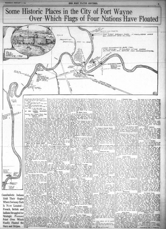
Five forts were built all located within a square mile of the center of the current city of Fort Wayne. The current fort is a replica of the 1815 "Whistler's Fort." The reason for the first fort was to protect the fur trade.
"The exact spot, or, rather the very bounds of the fort grounds are not, at this distant period, to be ascertained; but enough is certainly known to advise the interested that the ground selected for this [Wayne's] fort is that which is designated on the city of Fort Wayne as lots 11, 12 and 13, within Taber's addition, laid out 15th April, 1835, being at the northwest corner of Clay and Berry streets, near where Clay street crosses the canal [Nickel Plate railroad tracks] at the Maumee bridge [then at Main street] just below the junction of the St. Joseph and St. Mary's. [Lot 11 is now occupied by the new building of the Western Newspaper Union, erected in 1916. Calvin K. Rieman states that when his father purchased this lot in the seventies and commenced an excavation on the property, he dug out the fragment of a pole, set deep in the ground, which the late Franklin P. Randall believed to be the flagpole of Wayne's original fort. Mr. Dawson, writing in 1872, says that this stump of a pole was doubtless the remnant of one of the liberty poles erected by the whigs in honor of General Harrison in the summer of 1840, when "this place, as others in the west, ran up so many poles that the traveler approaching the town was reminded of the spars of shipping in some harbor."] This [Wayne's] fort was of log construction, well located but not very safe. The location commanded the Maumee for half a mile below the junction, and the mouth of the St. Joseph and the St. Mary's. It was small, and, not serving the purpose, was torn down about 1804 [really in 1800] and a new one built on what is now lot 40, in the addition named above [Taber's] by Colonel [Thomas] Hunt. [Lot 40 is almost identical with Old Fort park. It seems very probable that the troops occupied the original fort during the period of construction of the second fort, so there were two American forts standing at the same time, [separated by perhaps three hundred feet of space.] This was taken down in 1817 [really in 1815-1816] by Major Whistler and rebuilt in a most substantial manner. From the best information, it seems to have enclosed an area about 150 fee square in pickets ten feet high, and set in the ground, with a block house at the Southeast and Northwest corners, two stories high. The second floor projected and formed a bastion in each where the guns were rigged; that on the southeast commanding the south and east sides of the fort, and that on the northwest the north and west sides. The officers' quarters, commissary department and other buildings located in the different sides, formed a part of the walls, and in the center stood the different sides, formed a part of the walls, and in the center stood the liberty pole on which was placed a metal American eagle, and over that floated the Stars and Stripes of the United States.
"The plaza, in the enclosure was smooth and gravelly. The roofs of the houses all declined within the enclosure after the shed fashion, and to prevent the enemy from setting it on fire, and, if fired, to protect the men in putting it out; and the water which fell was led in nicely made wooden troughs, just below the surface of the ground, to the flagstaff, and from thence led by a sluiceway to the Maumee.
"It is thought it left out a small portion of the old ground [that is, when Major Whistler rebuilt the fort he did not include all of the ground covered by the fort as built by Colonel Hunt], for it is definitely known that the southwest corner of the new fort was exactly at the corner of lot 40, the pickets running south of east, toward John Brown's blacksmith shop, and near where the shop now stands [1858], and where was one of the forts [blockhouses]. The east side ran to a point on the north bank of the canal, then west to the second fort and then [south] to the place of beginning.
"The stone curbing of the old well may yet be seen [1858] in the edge of the south bank of the canal and near the northwest corner of the fort. [In June, 1847, the Fort Wayne city council paid Dennis Dumean $1.50 for "filling up well at old fort"]. The canal cut off the north end of the fort, by which the pickets were removed, and this ancient relic invaded about 1833.
"Commencing at the north and at the upper side of the fort was a fine wagon track that ran obliquely down the bank, landing near lots 1, 2, 3, 4, 5, and 6, Taber's addition, and just below and about the south end of the present bridge over the St. Mary's at that place. [The bridge, at that time, 1858. crossed the St. Mary's at Lafayette street. The lots mentioned compose the unoccupied south bank of the St. Mary's running east from the Spy Run bridge. This was known for many years as the pirogue landing.]
"The fort itself was one of the most substantially built in the west. Attached to it was the commanding officers' garden of about one acre, which was on the west, including what are now lots 35, 36, 37 and 38, Taber's addition. * * * The company's garden extended to the west of that of the commanding officer, and ended about where the Hedekin house now is [Barr street], embracing, perhaps, lots 30, 31, 32, 33, 34, 26, 27, 28 and 29, County addition, and was most highly cultivated.
"The road ran about where the canal does now [right-of-way of the Nickel Plate railroad], from what is now the northeast corner of Columbia and Barr streets, eastward to the fort.
"To the south of the fort, where F. P. Randall, Esq., now lives [northwest corner of Lafayette and Berry streets), lots 35, 26 and 37, County addition, and lots 11, 12 and 13, Taber's addition, was a graveyard, where were buried many persons—officers, citizens and soldiers, who had theretofore died. [It will be observed that this graveyard included the area occupied by Wayne's fort.] * * * Another place of burial was that now occupied by the Times building [1858] and block contiguous—northeast corner of Columbia and Clinton streets, where many whites, children and Indians were from time to time buried—the bones of whom have been lifted as workmen have dug for foundations for building."
A later observation by the same writer is as follows:
"The timbers [for the rebuilt fort] were cut by the troops on the grounds now [1858] held and occupied by H. B. Taylor, James Embry, Samuel Hanna, and that between here and there on the east of town. It was hauled by the aid of oxen, ropes used instead of chains, and raised by the troops into officers' quarters, commissary departments, blockhouses, etc. The pickets were 12½ feet long and were put in sets of six, with a cross-piece two feet from the top, let in and spiked, and a trench dug 2½ feet deep, into which they were raised. A part of the old was taken down at a time and replaced by the new. It was in this year [1815] that a small log house was built in what is now Barr street, near the corner of that and Columbia, and was located within range of the fort, that it might be razed if it were attacked by the enemy. This primitive building was afterward set out of the street and stood for a long time as a part of Washington hall [Ewing's Tavern], facing Barr street."
The late George W. Brackenridge thus described the appearance of the fort in 1830:
"Timbers of the old fort were standing in 1830. They were about a foot square, eight or ten feet high, pointed at the top. The stump of the flagpole was also in front of the two blockhouses which occupied the high ground at the east end of Main street, north side—both built of hewed logs. These buildings were two stories high, consisting of two large rooms below, same above, both lengthwise north and south. The one farthest from the street was taken down when the canal was dug. The other stood many years afterward, occupied by tenants. A blockhouse for storing arms and ammunition with an all-round over-jet second story, stood about seventy-five feet west of the two aforementioned."
"A common road ran down along the canal and across the old fort ground, between the old well and the only building of the fort then standing. This building stood on the vacant ground [now Old Fort Park]; it was two-story, and had been changed from a shed to a conical roof. It had been used originally for officers' quarters. A broken pole stood in the center of the parade ground, on which the Federal flag had been originally hoisted. The pickets which had enclosed the ground had nearly all been removed, yet the line where they stood was marked. A post at the gateway at the southwest corner of the stockade on the alley between Berry and Wayne street, was standing. These pickets and the logs which had composed the other buildings within the pickets, had all been removed by the people for building purposes."
The last of the buildings was torn down in 1852. Early in that year enough of the original stockades and buildings remained to arouse a vigorous but ineffectual protest against their final destruction. In that year Dr. G. W. Bowen, writing in the Laurel Wreath, a local publication, gave utterance to his sentiments in verse. The title of the poem was, "Spare Wayne's Fort." The opening stanza follows:
Why tear it down and spare it not?
Are other days so soon forgot?
Are other scenes no more to be
Brought back to sweet, blessed memory?
And must those walls that served so well
To shield at night from savage foe
That daring band, be leveled low?
The silent truth forbid to tell!
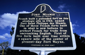
Where the First French Forts Stood on page 34 of The pictorial history of Fort Wayne, Indiana : a review of two centuries of occupation of the region about the head of the Maumee River by Griswold, B. J. (Bert Joseph), 1873-1927; Taylor, Samuel R., Mrs, Publication date 1917 on Archive.org. A map drawn by Father Jean Bonnecamps while on the site of Fort Wayne in 1749 (forty-five years before the coming of General Wayne) shows that the French fort of that period (Post Miami) stood on a site which may now be described as a point on the right bank of the St. Mary's river, a short distance north of the Nickel Plate railroad tracks (see map). The commandants in succession appear to have been Jean Baptiste Bissot, Sieur de Vincennes (1697), Francois Morgane, Sieur de Vincennes (1725), Ensign Douville (1734), Ensign Dubuisson (1747), M. de Raimond (1748). Ralmond, in 1750, abandoned the place and erected the last French fort on a site at the junction of the present St. Joe boulevard and Delaware avenue, on the St. Joseph river, a point also within the present city of Fort Wayne.
Fort Wayne’s first fort was built as a dream of the French, and especially the renowned 17th century explorer Robert Sieur de La Salle, to create a wilderness empire that arced through the Great Lakes and the Mississippi River valley from Quebec to New Orleans. Is the first sentence of the First Fort of the Fort by Tom Castaldi, local historian posted October 9, 2014 on History Center Notes & Queries blog. Fort Miami (Indiana) at Wikipedia, The Free Encyclopedia.
French built a palisaded fort on this strategic site in 1722; named Fort Saint Philippe des Miamis. One of three French forts built in what is now Indiana to protect French fur trade from encroaching English. First of five forts built over time within a square mile of the center of present-day Fort Wayne.
Side two:
Nearby confluence of St. Mary's and St. Joseph's rivers forms Maumee River, a strategic central part of the waterways system connecting Great Lakes regions with Mississippi River Valley. Using a portage between Maumee and Wabash rivers, travelers could journey nearly 2,500 miles by water from French Canada to Louisiana.
Page 43 in Chapter V--1733-1749 The Last French Posts of the Site of Fort Wayne is WHERE THE LAST FRENCH FORT STOOD — SCENE OF THE HOLMES MURDER OF 1763 in The pictorial history of Fort Wayne, Indiana : a review of two centuries of occupation of the region about the head of the Maumee River by Griswold, B. J. (Bert Joseph), 1873-1927; Taylor, Samuel R., Mrs, Publication date 1917 on Archive.org. The landscape is a view looking up the St. Joseph river in Fort Wayne from a point near the junction of St. Joe boulevard and Delaware avenue. On the high ground at the right. M. de Raimond erected the last of the French forts in 1750. Raimond at that time abandoned the site on the St. Mary's river, near the present Nickel Plate railroad tracks. It was from the new fort that Raimond wrote in alarm to the French governor of Canada that "nobody wants to stay here and have his throat cut: if the English stay in this country we are lost — we must attack and drive them out." In 1760, the fort fell to the British. Ensign Robert Holmes, three years later, was murdered by the Indians and the men of the garrison were taken prisoners. The Murder of Holmes is discussed on page 60 .
Miamis, Shawnees, and Delawares camps shown in View of the Maumee Towns Destroyed by General Harmar October 1790 Map of Kekionga, before its destruction, drawn by Ebenezer Denny ,1761-1822, Osprey Publishing as File:Map of Kekionga.jpg from Wikipedia, The Free Encyclopedia. See our page Indians - Native Americans of Allen County, Indiana.
THE FIRST FORT--We know there is confusion about Fort Wayne, and we'd like to clear it up. Historic Fort Wayne is a wonderful recreation of the fort rebuilt in 1815-1816 by Major John Whistler, the Fort's Commandant. The first fort was ordered by General Wayne in 1794, on the high ground overlooking the confluence of the Saint Mary's and Saint Joseph Rivers, and the Miami Tribe's "town" of Kekionga; it was dedicated on October 22, 1794, the day after the General left. A marker at the corner of what is now the intersection of Berry Street and Clay Street, seen in the photo below, shows the location of that original fort. That version of the fort was hastily built, leading to it being reconstructed four years later. Colonel Joseph Hunt began the rebuild with a second fort at the Three Rivers in 1798, two years after the General's death. It was built on the site just east, and slightly south, of FWFD Fire Station #1, downtown on Main Street. So, the Historic Fort Wayne on Spy Run is a replica of and modeled after Whistler's fort, the third fort built in the area to honor early settlers and soldiers.
Following General Anthony Wayne's victory at the Battle of Fallen Timbers, the Legion of the United States under Wayne's command moved into present-day Indiana. Wayne selected a site for a fort at the Miami town of Kekionga.
The site was strategically and militarily located at the confluence of the St. Joseph, Saint Mary's, and Maumee Rivers. Wayne sought to exert American influence and control in the region over the claims of indigenous peoples and the British. Major John F. Hamtramck was placed in command of 100 soldiers stationed at the fort.
Following the arrival of the Legion of the United States at the Confluence of the Three Rivers in September 1794, General Anthony Wayne ordered the first American fortification in present day Allen County built across the river from the Miami Indian village of Kekionga, now the northwest corner of Berry and Clay Streets. Exactly 225 years ago today, on October 22, 1794 the completed fort was dedicated with a military parade and the firing of 15 cannon rounds representing the 15 states of the union. The date was selected because it marked the four year anniversary of the defeat of American forces under the command of General Josiah Harmar by the Miami under the command of Chief Little Turtle at the Battle of Kekionga. Following the ceremonies, Wayne departed, leaving the fort under the command of Colonel John Francis Hamtramck, who chose the name “Fort Wayne” in honor of his military commander. Today we celebrate the 225th anniversary of the dedication of Fort Wayne! #sociallyhistory
The last paragraph of Blogging Hoosier History states: After the Battle of Fallen Timbers, John Whistler and his wife resided in the garrison at Fort Wayne, and here, in 1800, George Washington Whistler was born, one of fifteen children. George became “Whistler’s Father” the father of James Abbott McNeill Whistler whose renowned oil on canvas, “Arrangement in Grey and Black: Portrait of the Painter’s Mother,” is known to the world as “Whistler’s Mother.” [ accessed January 26, 2024 ]
George Washington Whistler (May 19, 1800 – April 7, 1849) was a prominent American civil engineer best known for building steam locomotives and railroads.[2]He is credited with introducing the steam whistle to American locomotives.[3] Did he name it whistle from his name Whistler? Accessed January 26, 2024 on Wikipedia, The Free Encyclopedia.
Born in 1800, George Washington Whistler was a West Point graduate. A soldier, draftsman, engineer and builder with a knack for constructing railroads, he is credited with bringing the steam whistle to American locomotives. So wide was his renown in 1842— about the time of this little painting—that Czar Nicholas I hired him to build the Moscow-St. Petersburg railway. George Washington Whistler died there doing so, much too young, in 1849. Copied from Getting to Know Whistler’s Father Whistler’s mother is a superstar. But the painter’s dad has languished in obscurity—until now, Jeff MacGregor, June 2014 on Smithsonian Magazine.
Does the name "Whistler" sound familiar? Major John Whistler was Commandant of Fort Wayne at the time the third fort was built in 1815-1816. The fort that Whistler had built was the last in the Three Rivers Region, and on April 19, 1819, was abandoned by the U.S. Army. The name "Whistler" may sound familiar because Major John Whistler was the father of George Washington Whistler, and the grandfather of James Abbott McNeill Whistler whose oil painting on canvas became known to the world as "Whistler's Mother". (Image courtesy of National Gallery of Victoria.)
[ If Whistler's mother is the mother of the artist and he was a grandson of the Commandant, this means she was the daughter-in-law of the Commandant since she was the wife of the son of Commandant Major John Whistler ]
James McNeil Whistler submitted his painting titled “Arrangement in Grey and Black” to the Royal Academy of Art, seeking to have it exhibited at the 104th Exhibition of the Academy in London in 1872. The Academy was not impressed, however, and had decided to reject the painting, before relenting and grudgingly accepting it after the director of the National Gallery, Sir William Boxall, threatened to resign if Whistler’s painting was not included in the exhibition.
Unwilling to display a portrait titled an “arrangement,” the Academy added an explanatory subtitle and displayed it (in the back of the gallery) as “Arrangement in Gray and Black: Portrait of the Painter’s Mother.” Of course it is known today as “Whistler’s Mother,” one of history’s most famous paintings.
Whistler was living in London when he created the painting, having moved to Europe to pursue a career as an artist after being expelled from West Point. According to Whistler, after a model he had hired failed to show up for an appointment, he asked his 67-year-old mother to stand in for her. With no intention of doing so, he ended up creating one of the iconic representations of motherhood.
In 1891 Whistler pawned the painting, and it was purchased by a Paris museum. Today it is displayed at the Musée d’Orsay. It is widely considered to be the most famous painting by an American artist held by a museum outside of the United States.
On this day in 1803 (April 13, 1803) John Johnston and his wife, Rachel Hoping Robinson Johnston, lost $414.50 when the Factor’s house at Fort Wayne was burnt down along with much of the nearby Factory or government warehouse. Several Indians were arrested. The one who set fire to it admitted the act had been committed at the instigation of Canadian or British traders who resented the US government's interference with established trade in the area.
Color photo is of the restored fort, which can be visited today.
You can learn more about General Wayne and the history of Fort Wayne by checking out Historic Fort Wayne. You can also read Richard Battin's fascinating article "Gen. Anthony Wayne helped the nation grow west" here: Gen. Anthony Wayne helped the nation grow west
The History Center has a wonderful collection of historical images. Because the society was founded in 1921, it acquired many invaluable artifacts from the children and grandchildren of Fort Wayne's earliest pioneers. Its photographic collection is full of treasures, and one item in particular of special value is a daguerreotype of a blockhouse from the old 1816-era fort, actually one of two daguerreotypes of it in the collection.
In the fall of 1852, Charles C. Stevens stopped by the crumbling building and photographed his friends seated in front. Located on Main Street near the present site of Fire Station No. 1, the old fort had been abandoned by the U. S. Army garrison in 1819. During the ensuing years several families lived in the structures, including, it is said, some Irish immigrants, but the structures soon became derelict. By the 1850s, little of the fort was left. The pallisades were long gone, and scavengers had taken for souvenirs many of the original timbers. Local residents used other pieces apparently as building mateirals and beams in local houses, including the Merchant Huxford house on Spy Run Avenue, which is still standing.
RUINS OF THE LAST BLOCKHOUSE OF OLD FORT WAYNE, IN 1852.
As far as the writer has been able to learn, the original daguerreotype from which the above pen drawing was made is the only existing photographic picture of any of the buildings which formed a part of old Fort Wayne. The daguerreotype Is owned by Mrs. Adam Link, of Fort Wayne, who says of It:
"The picture was made by Charles Stevens, of Kennebunk Port, Maine, who was here as the guest of his cousin. Mrs. O. L. Starkey, my mother, who was then Miss Hannah Fairfield. On the day the picture was made, 'Charley' Munson (later prominent in the affairs of the county, but then a mere lad) was driving his cow to the pasture In 'the old apple orchard," in the present Lakeside. My mother and several others joined him for a walk. When they reached the ruined blockhouse, Mr. Stevens made the picture. The man at the top Is John Fairfield, my uncle. The others, from left to right, are Amanda Henderson (Mrs. Bloomhuff) Addle Fairfield (Mrs. H. .T. Ash). Priscilla Fairfield (Mrs. A. S. Hall), Hannah Fairfield (Mrs. O. L. Starkey), and 'Charley' Munson."
Miss Lizzie Johnson Says: "I am certain this building was torn down in 1852. On returning from a vacation in the summer of that year, we found everybody saying: 'They've torn down the old fort.'"
B. G. Anderson says of this building: "When we children came to Fort Wayne In 1846, with my father, Calvin Anderson, first landlord of the Hedekin house, this log building was still in good repair and was occupied by two Irish families. The Carroll family and Mr. Donovon, with his children. Tim, Mich and Ellen, were the last to make their homes In the historic structure. The building faced the east, overlooking the Maumee."
John H. Jacobs, of Spy Run avenue, also remembers this building well, as It was standing when he came to Fort Wayne. At the present time, there Is a general feeling of deep regret that the fort was allowed to go into decay. The older residents explain the matter by the statement that the course of the Wabash and Erie canal required the destruction of one of the blockhouses and a palisade section, and that In the later years the ruined, dilapidated buildings became the rendezvous of undesirable citizens. The last building, shown in the Illustration, was torn down by John Fairfield In 1852. Some of the wood was made into walking sticks which are preserved as relics.
The discussion referenced the Old Apple Orchard discussed in our Apple Tree article.
See our Huxford House section on possible old fort remnant timbers.
The late George W. Brackenridge thus described the appearance of the fort in 1830 :
"Timbers of the old fort were standing in 1830. They were about a foot square, eight or ten feet high, pointed at the top. The stump of the flagpole was also in front of the two blockhouses which occupied the high ground at the east end of Main street, north side — both built of hewed logs. These buildings were two stories high, consisting of two large rooms below, same above, both lengthwise north and south. The one farthest from the street was taken down when the canal was dug. The other stood many years afterward, occupied by tenants. A blockhouse for storing arms and ammunition with an all-round over-jet second story, stood about seventyfive feet west of the two aforementioned."
Writing of 1838, John W. Dawson says :
"A common road ran down along the canal and across the old fort ground, between the old well and the only building of the fort then standing. This building stood on the vacant ground [now Old Fort Park] ; it was two-story, and had been changed from a shed to a conical roof. It had been used originally for officers' quarters. A broken pole stood in the center of the parade ground, on which the Federal flag had been originally hoisted. The pickets which had enclosed the ground had nearly all been removed, yet the line where they stood was marked. A post at the gateway at the southwest corner of the stockade on the alley between Berry and Wayne
street, was standing. These pickets and the logs which had composed the other buildings within the pickets, had all been removed by the people for building purposes."
The last of the buildings was torn down in 1852. Early in that year enough of the original stockades and buildings remained to arouse a vigorous but ineffectual protest against their final destruction. In that year Dr. G. W. Bowen, writing in the Laurel Wreath, a local publication, gave utterance to his sentiments in verse. The title of the poem was, "Spare Wayne's Fort." The opening stanza follows :
Why tear it down and spare it not?
Are other days so soon forgot?
Are other scenes no more to be
Brought back to sweet, blessed memory?
And must those walls that served so well
To shield at night from savage foe
That daring band, be leveled low?
The silent truth forbid to tell !
October 30, 2013 - Fort Wayne is the answer on the Jeopardy television show A log stockade made by a certain mad revolutionary war general in 1794 gave this city his name. See October 30, 2013 photo on Visit Fort Wayne Tweet on Twitter and Mitch Harper Tweet.
Street View photo from Google map shows the large rock with the marker on Clay Street at East Berry Street which is one block south from the last two forts (Stop #11) marker on Main Street just west of Clay Street. The History Centerbuilding is two blocks west on East Berry Street. Anthony Wayne’s Fort (Stop #10) by ARCH ( Architecture and Community Heritage) includes the Building and Dedication of Fort Wayne map image shown above. It states: Older Historical Marker reads: “The site of General Anthony Wayne’s fort dedicated Oct. 22, 1794. It was the first United States fort near “Three Rivers.” This fort commanded the shortest portage between the St. Lawrence and the Mississippi systems. A portage known to the Indians as “Glorious Gate,” and a strategic crossroads in early trade and exploration.” The Site of General Wayne's Fort Dedicated October 22nd 1794 is at The Historical Marker Datatbase HMdb.org.
Street View photo from Google map shows the plaque for the Old Fort Park location in front of the Old Fort Well by a large tree just east of Fire Station #1 on Main Street east from Clay Street looking north on Main Street at the overhead Nickel Plate railroad tracks. Last Two American Forts (Stop #11) with audio: “Last Two American Forts” featuring Tom Castaldi. Courtesy of WBNI-Fort Wayne on the ARCH ( Architecture and Community Heritage) Central Downtown Trail. The last paragraph states: The fort was built on the same location as the Hunt fort. In 1819, all troops were transferred to other posts, leaving Fort Wayne abandoned. Major Stuckney, the Native American agent, was in care of the fort; he leased some of the rooms to families or individuals who needed them. At one point Reverend Isaac McCoy, a Baptist missionary, held a school in some of the rooms of the fort. As the years went on, logs from the fort were removed by people for building purposes and in the 1830s the fort grounds were disturbed by the digging of the Wabash and Erie Canal bed which passed through the garrison. The fort remained at its location until it rotted down and in 1852 the last building was torn down; souvenir canes were made from some of its timbers. An 1852 daguerreotype photograph of a blockhouse from the old 1816-era fort is shown above. The Last Two American Forts / The Siege of 1812 is at The Historical Marker Datatbase HMdb.org. This location on Main Street just west of Clay Street is the same location as the Old Fort Wayne Well at Old Fort Park.
Page 225, NOTES ON CHAPTER XVII. (3) Me-te-a died in Fort Wayne in 1827. The late Louis Peltier made the casket in which the body was buried. Peltier, who was born within the walls of the old fort, in 1815, conceived brush to grain the coffin.' " the idea of his life work while assisting to remove the skeletons of the fort soldiers from the military cemetery which was situated in the region of the "junction of the present Berry and Clay streets. This was while Mr. Peltier still was in his teens, and was engaged in learning the carpenter and cabinet- making trade with James Wilcox, whose shop was also the first under-taking establishment in Fort Wayne. In the beginning the undertaker was also the coffinmaker. The first person whose body Louis Peltier made the burial casket was Chief Me-te-a, whose tragic death was the result of taking - poison while conversing with friends in the silversmith shop of "Father" Be- quette. From the January (1880) issue of "The Casket," an undertakers' Jour-nal Published at Rochester, N. Y., the following interesting additional Infor-mation is taken:
"The coffine was of poplar and, as staing material was scarce at that time, Dr. Cushman furnished Venetian red. 'To gain the dark colr', said Mr. Petier, 'we burned oat straw and then secured General Tipton's whitewash brush to grain the coffin.'"
Soon after the burial of Me-te-a, Dr. Lewis G. Thompson had the body ex-humed in order to make an examination of the remains. "A noise was heard." says the late John W. Dawson, "which the company thought to be Indians: and. as they knew the savages were greatly hostile to such disinterments, they were at once panic stricken, and, quickly blowing out their lights, fled to the brush to await the denouement. False as the alarm proved to be. they were nevertheless suspicious of the nearness of danger. So, returning to the grave, they re-buried the body."
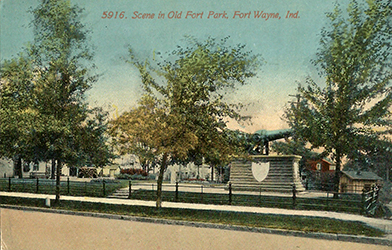
WHERE THE TWO STOCKADED FORTS WERE LOCATED. From the most reliable sources of information it appears certain that the original stockade erected by General Wayne's troops in September and October, 1794, occupied a site which included a portion of lots 11, 12 and 13, Taber's addition to Fort Wayne, and that the new fort, erected in 1800 by Colonel Thomas Hunt and rebuilt by Majors Whistler and Vose. included lot 40 — the present Old Fort Park. (See Chapter XIX).
Page 465, Old Fort Park, one of 12 Fort Park mentions in The pictorial history of Fort Wayne, Indiana : a review of two centuries of occupation of the region about the head of the Maumee River by Griswold, B. J. (Bert Joseph), 1873-1927; Taylor, Samuel R., Mrs, Publication date 1917 on Archive.org. OLD FORT PARK. The development of the present splendid park system of the city of Fort Wayne represents a continued and ofttimes discouraging effort extending over a half a century. The first piece of ground to be acquired for park purposes was the fractional lot No. 40, Taber's addition to Fort Wayne, purchased from Harry Seymour for $800. The little triangular spot — one-fifth of an acre — is the most treasured bit of ground in Fort Wayne, as it was a part of the site enclosed within the historic old Fort Wayne. Henry M. Williams later placed about the tract an iron fence and erected in the park a flagpole.
The fort at the three rivers by Snow, Dorothea J., 1909-, Publication date 1968, an Archive.org. FOREWORD In May, 1964, Pi Chapter of Psi Iota Xi Sorority made a challenge grant to the Allen County Fort Wayne Historical Society to research the historical data necessary to build an accurate reconstruction of the Old Fort. The grant was to be used, in part, to employ research scholars, to prepare and publish their findings and to bring to Fort Wayne for the first time a documented account of her earliest history. The resulting body of documents and source materials is now housed in the Historical Museum. It is on this Psi Ote Collection that Dorothea Snow has based her book, an accurate account of early Fort Wayne, written as a gift to the children of our city. Pi Chapter of Psi Iota Xi believes that bringing to life the story of the beginning of this community is as important a contribution as we could make to our fellow citizens. We are honored, therefore, to present Miss Snow's book to this and all future generations. We are proud to have had a part in preserving and bringing to our children their heritage.
Diary of Captain John Cooke, 1794 Allen County-Fort Wayne Historical Society, 1953, an Archive.org. The Foreword states: Primary source materials relating to General Wayne's sojourn at Fort Wayne are scarce. Extracts from the diary of one of his captains were published in the Fort Wayne Gazette eighty years ago.
Merchant-Huxford House (520 Tennessee Ave.) is threatened with vacancy and decay. The house was the home of one of Fort Wayne's early mayors and legendarily contains timbers from the last fort in Fort Wayne. from Endangered structures, Archie winners named published November 15, 2012 in The Journal Gazette newspaper but no longer online.
Major Francis Smith Belton (1791 - 1861) was a U.S. Army officer who served in a number of campaigns starting with the War of 1812. He had a fiery temperament and was twice convicted by court-martial. At least one case involved a dispute with a fellow officer. Both times he was reinstated to service.
In December 1816, while serving in NYC as a staff brevet major in the Dragoons, he was assigned as assistant inspector general to the post in Detroit. He arrived at Detroit on January 18, 1817 and spent the year based there but traveling to inspect the various Army posts reporting to Detroit. This picture is one of a series of five sketches he apparently made during this journey. The Fort Wayne view bears the date of 1816 and may either be an error or from an earlier unrecorded journey.
For Wall of Fame Wednesday we share the inside cover of the 1967 "HISTORIC FORT WAYNE IN PICTURES" a Coloring Book. Stop...
For Wall of Fame Wednesday we share the inside cover of the 1967 "HISTORIC FORT WAYNE IN PICTURES" a Coloring Book. Stop by at 1910 Saint Joe Center Road Suite 51 to see this...and sooooo much more! We'll even get your picture and add it to our album!
For "Wall of Fame" Wednesday we share another page from the 1967 coloring book HISTORIC FORT WAYNE IN PICTURES by the ALLEN COUNTY - FORT WAYNE HISTORICAL SOCIETY, INC.
[ Although the Indians had lived in peace and friendship with the French, the arrival of the English marked the beginning of troubled times. The English newcomers realized the importance of winning the Indians to their side if they were to gain contorl of the land around the threee rvers. The Indians were given guns and amunition and many deserted their French friends to aid the British. Thus it was that the French Post Miami was burned by the Indians in 1747. ]
The fort at the three rivers (1968) - Snow, Dorothea J., 1909-, "A project of Pi Chapter, Psi Iota Xi Sorority and the Allen County-Fort Wayne Historical Society in cooperation with the Public Library of Fort Wayne and Allen County."
March 23, 2017 a post by Historic Fort Wayne on Facebook posted a television screen shot: Big Bang Theory held their version of March Madness, with a ‘Elite Eight’ bracket for best Fort. Looks like we lost out to Fort Knox. Fort Cozy McBlanket won. How is your bracket doing?