
free genealogy since 1996
Allen County, Indiana Genealogy
Maps of Allen County, Indiana
Maps can show useful information such as locations of rivers, creeks and various natural features. Maps can also show human built structures ranging from city and town limits, to canals, bridges, streets, roads, and various improvements. City directories can add timeline information on changing population numbers, streets and numbering, government location, schools, when buildings were built, and businesses opened.
Maps can show useful information such as locations of rivers, creeks and various natural features. Maps can also show human built structures ranging from city and town limits, to canals, bridges, streets, roads, and various improvements. City directories can add timeline information on changing population numbers, streets and numbering, government location, schools, when buildings were built, and businesses opened.
Jump to: Additional Information, Allen County maps, Aerials, Copyright, Dave Rumsey, Sanborn maps, Other Sources, Trivia
December 14, 2015 post by the DAR Museum on Facebook:
Maps, like this one of VA over the fireplace mantle in the Virginia Period Room, often decorated walls in homes during the 1700s and early 1800s. Maps could be framed, but more commonly they were attached to wood rollers and hung from small brass rings. People most often hung maps in public spaces like a hallway, parlor, or dining room.
[ This is the Fry-Jefferson Map of Virginia first published in 1753 - this Jefferson was Thomas Jefferson's father.]
42 minute Allen County Info provides information on the iMap GIS Portal for Allen County residents briefly discussed on our Land Records page.
July 28, 2023 post by Allen County INfo on Facebook:
Last week the Allen County Commissioners recognized Dave Estes for an amazing accomplishment. Not only is Dave among the most elite in the country working in geographic information systems, or GIS, who have won a national SAG award, he is the only one in the world who has won it three times.
Allen County utilizes Esri's location intelligence software. Earlier in July, Dave traveled to the Esri User Conference where Allen County was selected from hundreds of thousands of users internationally for the coveted Special Achievement in GIS (SAG) Award.
Dave is the only full-time county employee managing the Allen County's GIS program. It is due to his innovative use of mapping and analytics technology that the county garnered the award.
Congratulations
, Dave Estes, for putting us on the map! (Pun intended)
To check out Allen County’s GIS map data, go to https://www.acimap.us/.
Pictured, left to right: Noah Miller and John Barnett - GIS Analysts for Resultant/DAI, Jack Dangermond – President and co-Founder of Esri, and Dave Estes – GIS Coordinator Allen County Indiana
The Fort Wayne Traffic Engineering Department web page has a bunch of useful maps and information worth checking out. https://www.cityoffortwayne.org/publicworks/traffic-engineering.html
Posted by Three Rivers Active Streets on Friday, March 22, 2024Friday, March 22, 2024 post by Three Rivers Active Streets on Facebook:
The Fort Wayne Traffic Engineering Department web page has a bunch of useful maps and information worth checking out.
FW Public Works Traffic Engineering Department
Want to see property lines or neighborhood boundaries, or to look up a tax bill for a particular property? Check out...
Posted by Three Rivers Active Streets on Friday, March 22, 2024Friday, March 22, 2024 post by Three Rivers Active Streets on Facebook:
Want to see property lines or neighborhood boundaries, or to look up a tax bill for a particular property? Check out Allen County iMap.
Allen County GIS https://acimap.us
Fort Wayne also has a mapped information site: City of Fort Wayne's GIS website: http://maps.cityoffortwayne.org
Populated Places
- Aboite Township: Dunfee
- Adams Township: Adams Station, New Haven
- Cedar Creek Township: Cedarville, Grabill, Hamilton, Hursh, Leo, Urbana
- Eel River Township: Potter Station
- Jackson Township: Baldwin, Edgerton, Townley
- Jefferson Township: Besancon, Maples, Tillman, Zulu
- Lafayette Township: Aboite, Aboite Station, Nine Mile, Zanesville
- Lake Township: Arcola, Hadley
- Madison Township: Boston Corner, Centreville, Hoagland, Massilon
- Marion Township: Hessen Cassel, Middletown, Poe, Williamsport
- Maumee Township: Bluecast, Edwardsville, Woodburn
- Milan Township: Fairport, Gar Creek, Milan Center
- Monroe Township: Dixon (OH), East Liberty, Monroeville
- Perry Township: Carrolls, Huntertown, Hunterville, Royville
- Pleasant Township: Sheldon, Yoder
- St. Joseph Township: History of Townships
- Scipio Township: none
- Springfield Township: Cuba, Halls Corners, Harlan, Maysville
- Washington Township: Academie, Wallen
- Wayne Township: Fort Wayne, Kekionga, Lewisburg, South Wayne, Waynedale
Allen County, Indiana Maps Chronologically
- Maps at Fort Wayne Community Development show all kinds of information from Annexation History to Census Data, Flood Plain, Neighborhood Association Quadrants, Political Boundaries, and more.
- iMap GIS Portal for Allen County residents, see video above, has maps for iMap Data Viewer, Engineering Viewer, Property Search, Election Board Viewer, Treasuer's Public Access, and City Parks, Recreation, and Trails Finder. If you go to Allen County iMap Data Viewer > Aerial > Historical Imagery Viewer > you can go back to aerial photos from 1938 through 2018 and Zoom through 14 different years of photos showing changes over time.
- Allen County, Indiana - Townships Map interactive Google Maps at RandyMajors.org.
- Allen County Maps available at the Indiana State Library Map Collection.
September 14, 2022 post by SAVI on Facebook:
Have you seen the Indiana State Library’s digitized historical map collection? There are lots of great maps of Indiana back to 1792 and Marion County maps back to 1831. This image is from the 1831 plan. Notice Courthouse Square in the current location of the City County Building. Indiana State Library Map Collection
- 1778 high definition zoomable map titled A new map of the western parts of Virginia, Pennsylvania, Maryland, and North Carolina; comprehending the River Ohio, and all the rivers, which fall into it; part of the River Mississippi, the whole of the Illinois River, Lake Erie; part of the Lakes Huron, Michigan &c. and all the country bordering on these lakes and rivers, at The Library of Congress.
-
Map of the United States, April 3, 1783. https://catalog.archives.gov/id/31491106 Record Group 76: Records of...
Posted by Today's Document on Monday, April 3, 2023April 3, 2023 post by Today's Document on Facebook:
Map of the United States, April 3, 1783.
https://catalog.archives.gov/id/31491106
Record Group 76: Records of Boundary and Claims Commissions and Arbitrations Series: Maps Related to the Northeastern Boundary of the United States
Image description: Map of the U.S. as of 1783, with states, geographical features, and Native American tribal territories labeled. Everything west of the Mississippi is just “Louisiana,” and some of the spellings are a bit off, like “Pensilvania.”
Image description: Zoomed-in portion of the map, showing how the cartographers hadn’t quite figured out the shape of Michigan yet.
Image description: Zoomed-in portion of the map, showing the Carolinas, Georgia reaching all the way to the Mississippi River, and East Florida/West Florida, which is not yet part of the U.S.
- Allen County Plat Books (Countywide and Published for Public Distribution) and their Locations in the Genealogy Center is a list of maps from 1855 to the present available at the The Genealogy Center at the Allen County Public Library in Fort Wayne, Indiana.
- History Center Digital Collection on the mDON mastodon Digital Object Network has many useful collections including Fort Wayne (Ind.) -- Maps, Streets -- Indiana -- Fort Wayne -- Maps, and Railroads--Indiana--Fort Wayne--Maps.
- Kekionga, 1697-1824 at ACGSI.org
- Indiana Fort Wayne : ms. map of Fort Wayne said to have been made on July 18, 1795, for General Anthony Wayne at the The Library of Congress. The Notes states:
the first American post, built in 1794 and named for Anthony Wayne after his victory at Fallen Timbers, was located across the St. Marys from the old Miami village of Kekionga and the remains of old Fort Miami, at the present intersection of Clay and Berry streets"--Ency. of Historic Forts, p. 281-282.
This was drawn about nine months after Anthony Wayne built his fort at the NW corner of today's Clay and Berry Streets
according to Randy Harter, Fort Wayne historian and authorcomment to the same photo posted September 18, 2017 on You are positively from Fort Wayne, if you remember... Archived group only visible to existing members on Facebook. -
1812 Era Map of Fort Wayne, Allen County, Indiana at the The Genealogy Center at the Allen County Public Library in Fort Wayne, Indiana. The same interactive map is online at David Rumsey Map Collection, Indiana University Image Collections Online Indiana Historic Maps, and Curtis Wright Maps. Was discussed March 24, 2022 on True Fort Wayne Indiana History on Facebook.

-
June 9, 2022 post by Indiana Archives and Records Administration on Facebook:
In 1816 mapmaker John Melish initiated a project to produce a map for each state and territory in the Union. The Indiana map was the first one that Melish published in 1817. This map shows how southern Indiana was the first to be settled. The misplacement of Lake Michigan caused confusion and contention for quite some time. This eventually resulted in the Toledo War between Michigan and Ohio, the only military conflict between two U.S. states outside of the Civil War.
Three settlement patterns in early Indiana - South 1790, Middle 1800-1830s, and North 1840s-1850s.
French explorers and fur traders were in Kekionga the Miami Indian village area before Anthony Wayne built Fort Wayne in 1794. The French built two forts beginning in 1722 before George Washington sent troops to eventually build three of the last five forts in what is now Fort Wayne in Allen County, Indiana. Many Pennsylvania German's came into Allen County leading to Fort Wayne becoming
a most German town
by the 1890s with many German Swiss Amish still living in rural Allen County.November 16, 2023 post by the Hancock County Historical Society on Facebook:
Did you know?...
Indiana, unlike other states, was settled in a South to North pattern rather than an East to West. This is an 1817 map of Indiana. One year after the state was granted statehood. You can see that most of the population is firmly established in the south.
There are actually three different cultural areas to the state depending on the people who settled the area and when they arrived.
The southern portion of Indiana was settled first when the Northwest Territory was opened up for settlement in 1790. The Ohio River along the southern border of the state is what encouraged this south to north settlement pattern.
The southern part of Indiana was settled primarily from people from the south...Kentucky, Tennessee, North Carolina and Virginia. This is where you will see a pre-ponderance of Southern Baptists, Methodists and some Quakers. These people tend to eat more traditional southern food...grits, cornbread, bacon, fried chicken and whiskey.
Indiana is known as the most southern of northern states.
The middle of Indiana was settled in the early 1800s up through the early 1830s. Indianapolis would become the state capitol in 1825. While there is some overlap of southern culture in Central Indiana, many of Central Indiana settlers were originally from the Mid-Atlantic states...Pennsylvania, New York, Maryland and neighboring Ohio.
There is a large Quaker population from Pennsylvania in this group. There are many Roman Catholics in this group and Lutherans. These folks tend to prefer the Mid-Atlantic diet, which has some heavy German influence. They prefer hamburger, tenderloin, wurst and sausage. They also like fish if it is available. Scrapple comes from PA. Sugar cream pie is a Quaker invention.
The northern part of Indiana was settled last in the 1840s and 50s. The Potawatomi, the Shawnee and the Miami were some of the last American Indian tribes to leave the state. The Potawatomi were forced out on the Trail of Death.
Also, northern Indiana was swampy, and the area needed to be drained before much settlement could happen.
Indiana's Pioneer time period technically ends around 1850 when we see population leaving the state to go out west during the Gold Rush of 1849. However, the last of northern Indiana was still being settled even then.
The folks who settled northern Indiana are your east coast people. They are from Rhode Island, Massachusetts, Connecticut, and from nearby Wisconsin and Michigan. These people tend to be Anglicans or Episcopalians or Presbyterians. There are many Scandinavian people in this group. They engage in the dairy business, so lots of cheese making. Apple and fruit orchards are more prevalent. Johnny Appleseed, a Massachusettes native, died in Fort Wayne. These people eat a lot of boiled foods. Pot roast is popular as are a variety of beans and lentils. Cider making is popular in northern Indiana.
You can hear the differences in speech too.
The people in southern Indiana have a more southern drawl. Central Indiana is home to the Hoosier dialect, where everyone "warshes" (with an R) their clothes. Northern Indiana has a more clipped speech like those who live in Da Region.
While there can be a mixture of all of these cultures even within the three regions, there still tends to be a preponderance of an "established cultural norm" due to our pioneer settlement pattern. These norms ring true even today...200+ years after the founding of our state.
Brigette Cook Jones
HCHS Board Member and
Past President
-
November 24, 2023 post shared by Military History of Fort Wayne on Facebook:
Tim J Fellure post November 24, 2023 to LIVING HISTORY IN THE WABASH COUNTRY
Interesting map showing the route to the Battle of Tippecanoe and the route to the Battle of Wildcat Creek or Spurs Defeat.
The Facebook map Indiana Country in the War of 1812 shown above is from page 27 in the book Indiana Country in the War of 1812 Indiana, "Hoosier State" : new historical atlas of Indiana, economic, social, political, for schools and libraries, business and industry in the Indiana Series in Two Parts; Volume I History and Government and Volume II The Historical Atlas by Olin Dee Morrison, History Department, Ohio University. 1958, E. M. Morrison, 152 Congress St., Athens, Ohio, USA at HathiTrust.org.
- Indiana State map 1819 - In 1816 mapmaker John Melish initiated a project to produce a map for each state and territory then in the Union. The Indiana map was the first one that Melish published in 1817. It was also the first map of Indiana produced by anyone. Rapid arrival of white settlers in the state led Melish to revise the map soon thereafter. The revised version is the one shown here. The map clearly shows that the pattern of settlement in Indiana was from south to north. The map also includes the township and range system, county names and boundaries at the time, Indian treaty lines and Native American villages, the major white settlements, rivers and creeks, trails and roads, forts, portages between rivers, and springs. Copied from Indiana State Map, 1819 at Maps in the Indiana Historical Society Collections

Indiana Historical Society Collections map - 1819 Ohio and Indiana zoomable map before northern Indiana had been divided into counties. Philadelphia : engraved & published by H.S. Tanner, [1819] at the The Library of Congress.
This map of Ohio and Indiana by Henry S. Tanner was published in about 1819, before northern Indiana had been divided into counties.
— LOCMaps (@LOCMaps) May 5, 2023
See it up close: https://t.co/Wv9wLCfx7j pic.twitter.com/XAdJkMpKnZ - Allen County Development Map, 1823-1835 at ACGSI.org.
- 1827 Indiana Map on our 1820s Timeline and Indians page.
-
1846 Map of Allen County
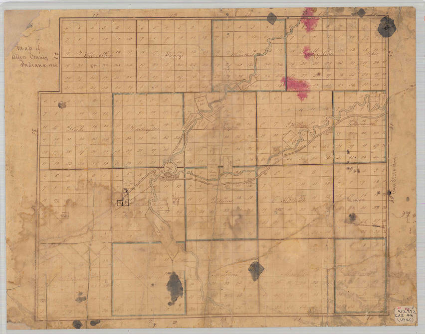
1846 Map of Allen County mapThis map is a hand-drawn map showing Allen County, Indiana in 1846. The map shows townships, some settlements and tribal reservations.
At the Indiana State Library Map Collection.
Also on our 1840 Timeline and Indian page. - Fort Wayne, panorama, 1857 at The Genealogy Center at the Allen County Public Library in Fort Wayne, Indiana
- Map of Allen County, Indiana, 1860 at The Genealogy Center at the Allen County Public Library in Fort Wayne, Indiana
- Bird's eye view of the city of Fort Wayne, Indiana 1868 at the The Library of Congress
-
1875 - zoomable Map of Allen County, Indiana, Item ID ISL_IND_MapL_AllenCo_1875, Description:This 1875 detailed map of Allen County, Indiana, was drawn by Samuel Morrison and include railroads, churches, schools, and canals. at the Indiana State Library Digital Collection.

-
1875 - zoomable Map of Allen County, Indiana . Description: This 1875 detailed map of Allen County, Indiana, was drawn by Samuel Morrison and include railroads, churches, schools, and canals. This file was contributed to Wikimedia Commons by Indiana State Library and Historical Bureau as part of a cooperation project. The donation was facilitated by the Digital Public Library of America, via its partner Indiana Memory. At Wikimedia Commons.org.

-
1876 Map of Allen County Andrea A.T. Baskin, Forster and Company, from the Dave Rumsey Map Collection - with over 100,000 maps of the world
- 459 page Illustrated historical atlas of the state of Indiana by Andreas, A.T. (Alfred Theodore), 1839-1900 is in the Fort Wayne Area History Collection at the History Center Digital Collection on the mDON mastodon Digital Object Network.
-
1876 map of Fort Wayne with Cedarville, Sheldon (currently known as Yoder), Arcola and New Haven from the David Rumsey Collection, can zoom in for more details, move the navigator, and go to original source of this Creative Commons License map.
- 1876 Map of Auburn, De Kalb Co., Ind. (with) Harlan Maysville, Monroeville, Edwardsburg, Huntertown, Hamilton. Andreas, A. T. (Alfred Theodore), 1839-1900; Baskin, Forster and Company, 1876, Dave Rumsey Map Collection
- Panoramic view of the city of Fort Wayne, Allen County, Indiana : 1880, looking south east by Ruger, A; Stoner, J. J; Beck & Pauli Publication date 1960 at Internet Archive and a cleaner more legible version at IndianaHistory.org.
- Allen County, 1880 at ACGSI.org
- Map of the City of Fort Wayne, Indiana Creator Goshorn, Date of Original 1885. Description Map of the schools, public buildings and factories and churches in Fort Wayne, Indiana. " Map compiled from the original records and corrected to date, by W.H. Goshorn for R.L. Polk && Co.'s Ft. Wayne City Directory". Map not dated; but date supplied by Allen County-Fort Wayne Historical Society. At History Center Digital Collection on the mDON mastodon Digital Object Network.
- 1895 US Atlas map
- R.L. Polk & Co's map of the city of Fort Wayne, Indiana, 1897 by R.L. Polk &Co Publication date 1897
-
Standard atlas of Allen County, Indiana : including a plat book of the villages, cities and townships of the county ... patrons directory, reference business directory ... by Geo. A. Ogle & Co. cn, Publication date 1898 on Archive.org. The same map with zoomable individual pages, directories of names, and photos in the Illustrations at Indiana Allen County 1898 Geo. A. Ogle, 1898 at Historic Map Works.
- Plat Book of Allen County, Indiana by Lindemuth, C. Ross, Publication date 1900 at Internet Archive
- 1905 Geological map of Allen County showing sand and gravel deposits. Historic Indiana Maps at IUPUI
- 1907 Griswold's birdseye view of the city of Fort Wayne, Indiana indexed for ready reference. B. J. Griswold, (Bert Joseph), 1873-1927 at The Library of Congress, click the map to zoom in for more detail. Excellent map with indexed locations for seeing where things were in early 20th century Fort Wayne. See it and more on our 1900 Timeline.
- Griswold's birdseye view of the city of Fort Wayne, Indiana indexed for ready reference by Griswold, B. J. (Bert Joseph), 1873-1927; Hixon, W. W Publication date 1907 on Archive.org is the same as Libary of Congress version above in book form from the Allen County Public Library.
- 1907 Plat book of Allen County, Indiana, 45 pages, Allen County Map Co., published Fort Wayne, Ind. : Allen County Map Co., 1907. Images on the Library of Congress web site.
- 1907 Plat Book of Allen County, Indiana American Memory version
- Allen County, Indiana from 1907 to 2011 Library of Congress over 30 Historical maps
- Map of the city of Fort Wayne, Indiana by Fort Wayne (Ind.). City Engineer's Office; Published 1910
- 1914 map of towns on Rootsweb.com
-
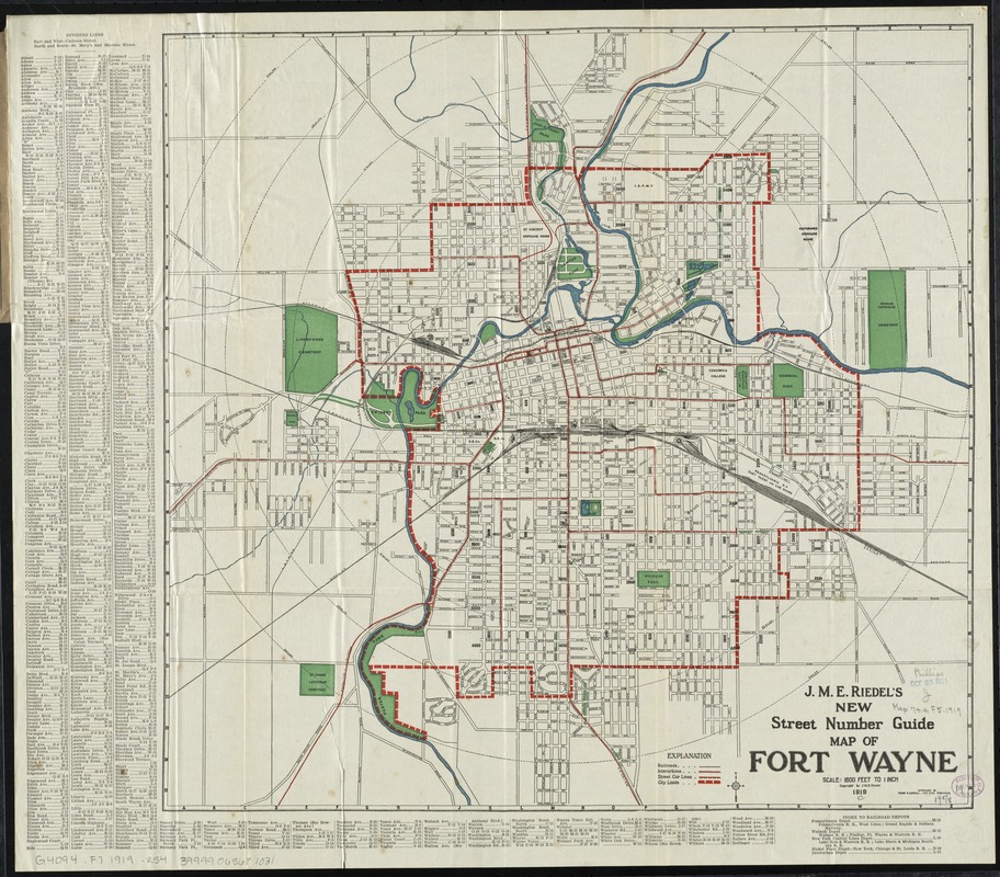
1919 J.M.E. Riedel's new street number guide map of Fort Wayne really large zoomable map at Digital Commonwealth Massachusetts Collection Online. A similar zoomable lower resolution J.M.E. Riedel’s New Street Number Guide Map of Fort Wayne at the We Do History digital collection by the Indiana Historical Society was discussed February 5, 2023 on True Fort Wayne Indiana History on Facebook.
One thing to keep in mind looking at old maps was what access was available at this time especially in regards to bridges around Fort Wayne due to having three rivers. Our Johnny Appleseed Newspapers page discusses the lack of a bridge over the St. Joseph River in Washington Township including a 1916 newspaper article asking for a bridge to built to provide access to the Archer Cemetery to allow maintenance of the cemetery.
- 1920 Plat Book of Allen County, Indiana Plat Books of Indiana Counties Vol. 1 at IUPUI, Allen County begins on page 20
- Map of Allen County, Indiana : roads by Darling, Orin M; Tonkel, William; Lindemuth, C. Ross; Publication date 1923; Collection allen_county; americana
- Map of the city of Fort Wayne, Indiana by Allen County (Ind.). Surveyor's Office; Published 1923; Collection allen_county; americana
- 1924 Atlas of Fort Wayne, Allen County, Indiana, 24 images, 79 pages, 19 plats, Randall, Frank M., published South Bend, Ind. : G.L. Hughes, 1924. Same book starts with the Cover page are images on the Library of Congress web site.
-
February 6, 2023 post by Genealogy Center on Facebook:
Check out this map of Fort Wayne's central business district in 1929! 📜 Do you recognize any of these businesses? View our digital map collection here: https://www.genealogycenter.info/fwacdb.php This map showing ground floor occupancy was prepared by Hilgeman and Schaaf Realtors, January 1929.
- 1930s map of Lincoln Tower downtown with more maps from Sanborn, of Pennsy RR and more in comments of February 7, 2017 discussion on You are positively from Fort Wayne, if you remember... Archived group only visible to existing members on Facebook.
- Fort Wayne Central Business District, 1929 at the Genealogy Center
- [Map of the city of Fort Wayne, Indiana] by Allen County (Ind.). Surveyor's Office; Published 1931
- 1932 A picture map of Indiana at Dave Rumsey Map Collection.
- 1935 Allen County Indiana showing property owners with county officials listed along the top at the Indiana State Library Map Collection on our 1935 Timeline.
-
November 16, 2022 post by the Indiana Historical Society on Facebook:
Happy National Indiana Day! We love to share Indiana history with the Hoosier public. Visit us in downtown Indianapolis to spend the day learning with us! https://indianahistory.org/ To celebrate our Hoosier state, below is a photo of a Tourist’s Pocket Map from 1839! What’s your favorite part about Indiana?
Zoomable map: The Tourist's Pocket Map Of The State Of Indiana Exhibiting Its Internal Improvements Roads Distances &c. By J.H. Young. Philadelphia: Published by S. Augustus Mitchell. 1839. Entered ... 1835, by S. Augustus Mitchell ... Pennsylvania. Sold by Thomas, Cowperthwait & Co. No 253 Market Street. Engraved by J.H. Young & F. Dankworth. at DaveRumseyMapCollection. The legend on the top right of the map shows the population of Allen County from the 1830 census was 996 with only 343,031 in the state of Indiana which is a less than the population of Allen County today! The legend on the left gives Steam Boat Route times.
- Zoomable 1936 Indiana state map from Wikimedia Commons.org from Indiana Department of Transportation on Wikipedia, The Free Encyclopedia.
- 1940 State Highway System of Indiana Department of Public Works
- Street Map of the City of Fort Wayne, Allen County, Indiana Creator Fort Wayne (Ind.). Office of the City Engineer Date of Original 1940-1949 at History Center Digital Collection on the mDON mastodon Digital Object Network.
-
March 8, 2023 post by Historic Southern Indiana on Facebook:
This Indiana tourism map shows a 1940s portrayal of dozens of Indiana landmarks. From the Indiana Historical Society Map Collection
- 1946 Indiana official highway map on Indiana Memory digital library at IN.gov is Zoomable.
-
September 20, 2023post by Historic Southern Indiana on Facebook:
What would you add to this vintage map of Indiana?
Joan Hostetler Collection, Indiana Album. Published in 1947.
- Street map of the city of Fort Wayne, Allen County, Indiana by Fort Wayne (Ind.). Office of the City Engineer; Green, Edward; Published 1959 on Archive.org.
- Suburban and Rural Additions, 1960 with index of additions, streets, and maps at the The Genealogy Center at the Allen County Public Library in Fort Wayne, Indiana.
-

Chart of navigation routes for Fort Wayne, Indiana established following the 1964 river cleanup program. Fort Wayne, Indiana, Navigation Chart & Historical Sites in the History Center Digital Collection on the mDON mastodon Digital Object Network.
- Indiana is on page 38-39 of the 206-page LIST OF CARTOGRAPHIC RECORDS OF THE GENERAL LAND OFFICE (Record Group 49) Compiled by Laura E. Kelsay The National Archives National Archives and Records Service General Services Administration Washington: 1964.
- 2000 era cartoon map of area businesses photos were posted August 9, 2017 on You are positively from Fort Wayne, if you remember... Archived group only visible to existing members on Facebook.
- Street Map of New Haven, Indiana, 1990s at The Genealogy Center at the Allen County Public Library in Fort Wayne, Indiana.
- Using maps in genealogy research by Jamie Dunn, Genealogy Division supervisor, posted October 13, 2022 on Indiana State Library blog.
Maps are an incredibly useful tool for genealogy and local history researchers. They can show insights into how people lived that are not readily apparent through other documentary sources. They can be used to help untangle research questions and show off your research in new ways. Maps are also fun to use in research; they are often colorful and provide a level of visual interest not often found in written documents.
- The Second Correction Line passes through northern Allen County, Indiana which accounts for the offset of the northern townships and the tiny Scipio Township. It can be seen by zooming in on this 1866 General Land Office map in the Dave Ramsey Collection of antique maps.
- A map of the old interurban lines in Allen County and a map of the canals to overlay onto current maps was a question posted October 14, 2022 on True Fort Wayne Indiana History on Facebook. The 1993 Tom Castaldi, local historian map is on our Wabash & Eric Canal page. Commenters shared the Indiana Electric Railways --11/22/14 - Google My Maps, the IndianaMap The Place for Indiana Geospatial Information at IN.gov and the magazine American Heritage Trusted Writing on History, Travel, and American Culture Since 1949 with an online Archive(1949-Present).
- February 22, 2023 discussion of local streets on True Fort Wayne Indiana History on Facebook.

Copyright
Research by Wilkin (2017) based on works in the HathiTrust Digital Library found that over 50% of works published in the U.S. between 1923 and 1964 were in the public domain due to lack of proper copyright renewal. An earlier work on the copyright renewal of Sanborn maps (Musser, 2014) found similar percentages while more recent research (Musser in press) indicates that, if Sanborn maps are excluded from consideration, the copyright renewal rate for maps published in the U.S. between 1923 and 1964 is less than 10%. Copied form
MORE MAPS ARE IN THE PUBLIC DOMAIN THAN YOU THINK by Linda Musser.- A Study of the Copyright Renewal Rate for Maps, Linda Musser, Fletcher L. Byrom Earth and Mineral Sciences Library, Penn State University, 105 Deike Building, University Park PA 16802 USA. Abstract: This study examines the copyright renewal of maps published in the United States from 1923 to 1950 and compares the results with a recent study of copyright renewals for books. Results indicate that, while the average copyright renewal rate for maps appears similar to that of books, the average was skewed higher by a single publisher whose renewal rate was much higher than average. With the data from that publisher excluded, the average copyright renewal rate dropped to 10%, meaning that a significant number of maps copyrighted in the United States in the first half of the 20th century are probably in the public domain due to lack of copyright renewal. This has implications for library map digitization projects, as much more content may be available for scanning and archiving than was previously thought.
Using Maps for Genealogy Research Nov 10, 2022 by Allen County Public Library on YouTube
This presentation will describe how maps in the collections of The New York Public Library and elsewhere can be used in genealogical research. We'll look at fire insurance maps and atlases, military and topographical maps, county maps and atlases, and other types of map to locate records, discover where our ancestors lived, and what their lives were like. Presented by Philip Sutton. Philip Sutton is a reference librarian at New York Public Library's Irma and Paul Milstein Division of United States History, Local History, and Genealogy, where he also teaches and writes about genealogy and building history research. Sutton is a visiting Assistant Professor at the Pratt Institute, where he teaches a class in Genealogy and Local History.